Manasquan Inlet Marine Forecast, NJ
Updated Sun Nov 15, 2026
Good boating all three days; light winds, small seas
Drop a pin on any spot in the world — free in the SeaLegs AI app.


Marine Forecast for Manasquan Inlet Nov 15–17, 2026
📋 Good boating all three days; light winds, small seas
Good all day. Northwest winds 9-13 knots, gusting to 23 knots midday, with choppy 2-foot seas at 3-second periods. Smoothest early morning.
Good all day. Northwest winds 8-9 knots easing to 5-6 knots by evening, with 1.5-foot seas from the north at 3-4 second periods.
Excellent all day. Light 4-7 knot northwest to west winds and about 1-foot seas at 4-5 second periods. Easiest day of the three.
Sunday through Tuesday all rate GO for a 12-hour trip, with northwest winds easing from 13 knots on Sunday to 7 knots by Tuesday. Seas stay small at 1 to 2.3 feet, though short 3 to 4 second periods make for some chop, especially Sunday. Model agreement is highest Sunday (85%), moderate Monday (72%) and good Tuesday (80%).
Recent days at Manasquan Inlet
Today’s Water at Manasquan Inlet
Sea surface temperature and chlorophyll around Manasquan Inlet, imaged fresh every morning. Water at the star is 59.6°F today, and chlorophyll of 2.49 mg/m³ reads as nutrient-rich green water at the spot.
Imagery: Nov 14, 2026 · rebuilt every morning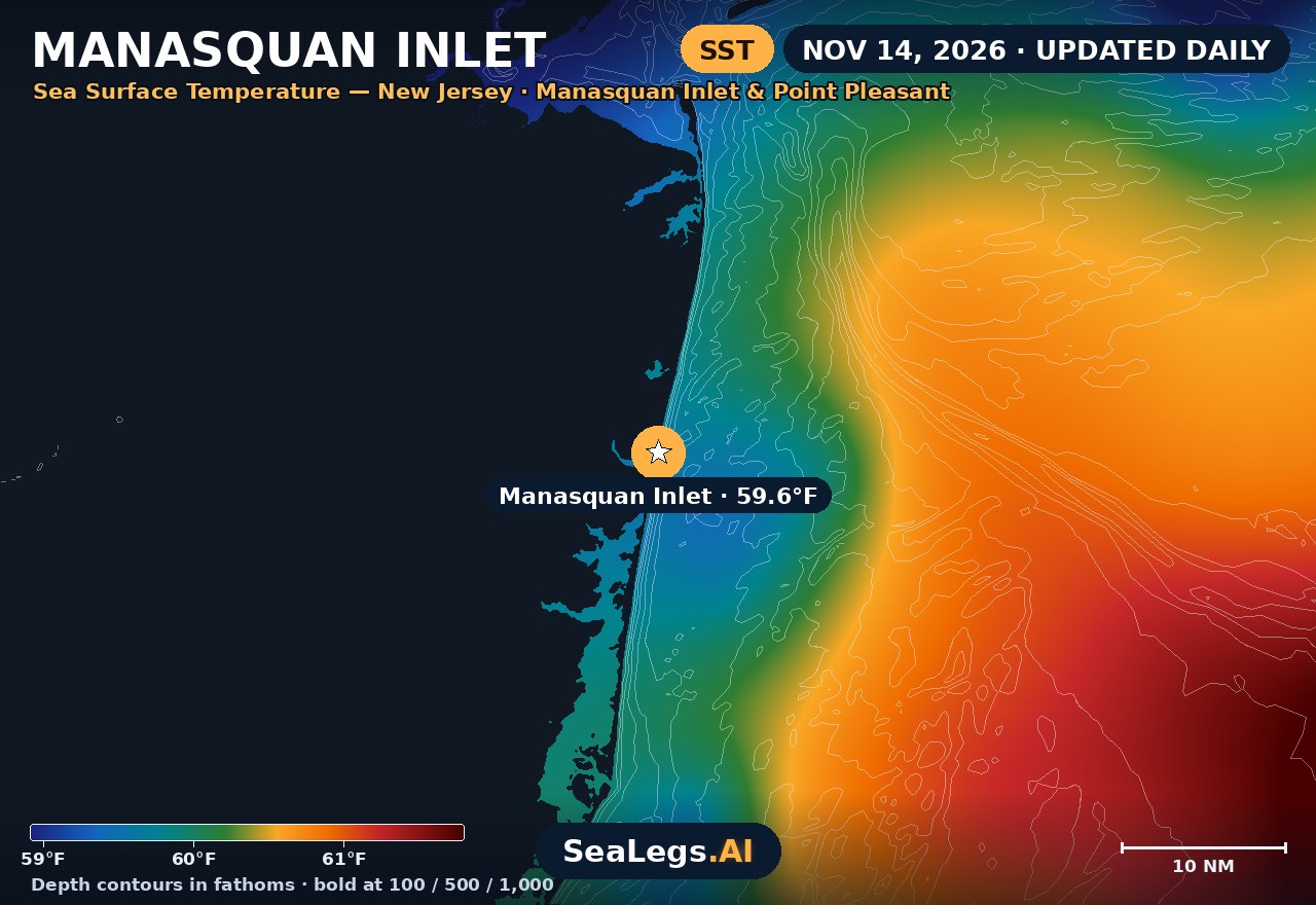
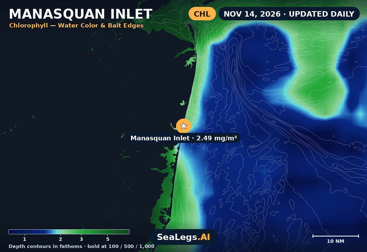
These charts show you the breaks. DeepCast reads them. A zone-by-zone AI fishing report for these exact waters — temperature edges, color changes, and structure, analyzed together.
Get the AI fishing reportSST and chlorophyll from the SeaLegs AI DeepCast satellite pipeline. Charts are a planning aid — always check the official marine forecast before making the run.
About Manasquan Inlet
Manasquan Inlet is the Atlantic entrance to the Manasquan River, with the borough of Manasquan on its north side and Point Pleasant Beach on its south. It is one of the busiest inlets on the Jersey Shore: the way out for the charter and party boat fleets of Point Pleasant Beach and Brielle, for boats coming down the river, and for traffic from Barnegat Bay through the Point Pleasant Canal.
The outlook below is for the water just outside the inlet. It updates every morning from the latest marine model data, and each day gets a plain GO, CAUTION, or NO-GO call — the same AI rating used in the SeaLegs AI app.
Reading conditions at Manasquan Inlet
Like every inlet on this coast, Manasquan is at its worst when the outgoing tide runs against an onshore wind or swell. Seas stand up short and steep between the jetties and off the mouth, so a day that reads moderate on the open beachfront can be a rough ride through the inlet itself. Read the wave period next to the height on every day card: a short-period sea is steeper and harder on a small boat than the same height in a long swell.
The inlet also changes. Sand builds up inside and near the mouth, shoals come and go with the wind and waves, and the Army Corps dredges it when they grow. Run the marked channel, not last season's chart. Inside, the Manasquan River and the canal stay usable on many days when the ocean does not. Use the three-day view above to pick the day: run outside when the window holds, and stay in the river when it closes.
This page is a planning aid, not a substitute for the National Weather Service coastal waters forecasts and warnings, or for Coast Guard Station Manasquan Inlet. Check both before you leave the dock.
Manasquan Inlet forecast FAQ
How is the sea at Manasquan Inlet today?
As of Nov 15, 2026, the SeaLegs AI verdict for Manasquan Inlet is GO. A good day for a 12-hour trip, any time works. Northwest winds run 9 to 13 knots, strongest from 10:00 AM to 3:00 PM with gusts of 20 to 23 knots, and seas of 1.8 to 2.3 feet at 3-second periods from the northwest, swinging north-northwest by afternoon. The short period makes for a choppy ride, so expect some bumps, but conditions stay in the good range throughout. Forecast confidence is high at 85%.
What marine forecast zone covers Manasquan Inlet?
Manasquan Inlet is the boundary between two NOAA coastal waters zones. North of it is Sandy Hook to Manasquan Inlet, and south of it is Manasquan Inlet to Little Egg Inlet, both out 20 nautical miles. The forecast on this page is built for the water just outside the inlet itself.
Does this forecast cover Point Pleasant Beach and Brielle?
Yes. The forecast point is just off the inlet mouth, between Manasquan and Point Pleasant Beach, which is the water the Point Pleasant Beach and Brielle fleets run out through. The Manasquan River inside the inlet will usually be calmer than shown here.
When is Manasquan Inlet rough?
When the outgoing tide meets wind or swell from the east, seas get short and steep in the inlet and off the mouth, even if the open-water forecast looks moderate. Shoaling near the mouth can make it worse. The forecast gives you the wind and waves. The tide tables, the marked channel and the Coast Guard station at the inlet tell you the rest.
How often is this Manasquan Inlet forecast updated?
The forecast on this page is rebuilt every morning from the latest marine model data, and the SpotCast card refreshes live in your browser. The date stamp above the outlook shows exactly when it was last generated.
What do GO, CAUTION, and NO-GO mean?
GO means conditions are favorable for most recreational boats. CAUTION means marginal — manageable for experienced crews in capable vessels, but check the wind, wave period and tide timing closely. NO-GO means conditions are hazardous for small craft and the trip is best postponed.
Can I get a forecast like this for my own spot?
Yes. In the free SeaLegs AI app you can drop a pin on any spot on Earth — a nearshore lump, a wreck, or a canyon edge — and get the same AI-rated marine forecast, plus fishing reports and trip planning.
What is the water temperature at Manasquan Inlet today?
As of Nov 14, 2026, the satellite-derived sea surface temperature at Manasquan Inlet is about 59.6°F, with chlorophyll around 2.49 mg/m³ (nutrient-rich green water). The SST and chlorophyll charts on this page are rebuilt every morning from the SeaLegs AI DeepCast satellite pipeline.
More offshore forecasts
Get this forecast for your own spot
Drop a pin on any spot on planet Earth in the free SeaLegs AI app — AI marine forecasts, fishing reports, and trip planning, rated GO / CAUTION / NO-GO.
📍 Get a Marine Forecast Near You →or download directly: