NJ Offshore Fishing ReportWeek of Sep 28 · out of Manasquan Inlet
Weekly report · published Monday, September 28, 2026
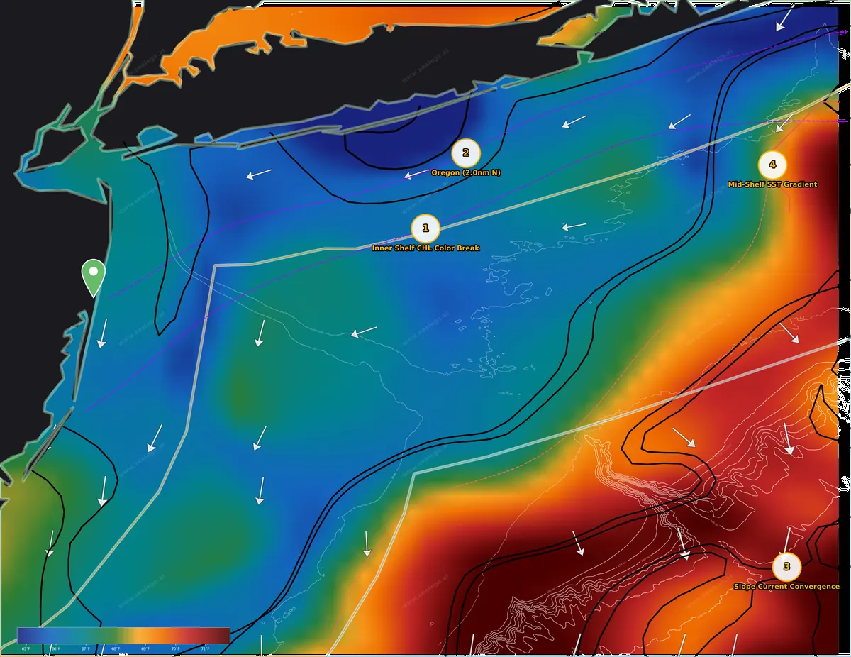
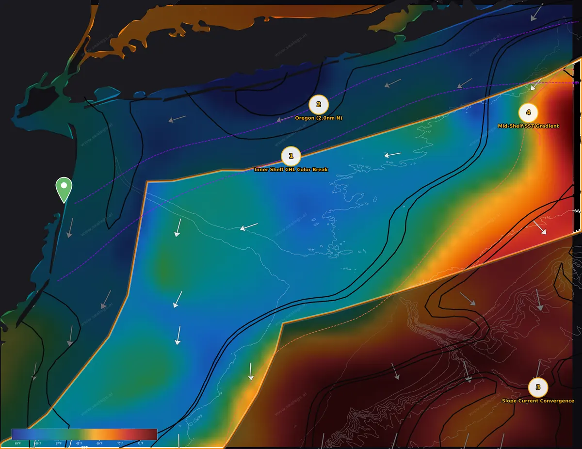
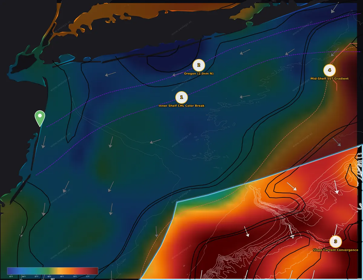
Sea surface temperature. Warm-to-cool breaks are where bait and pelagics stack.
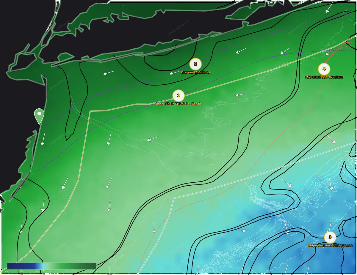
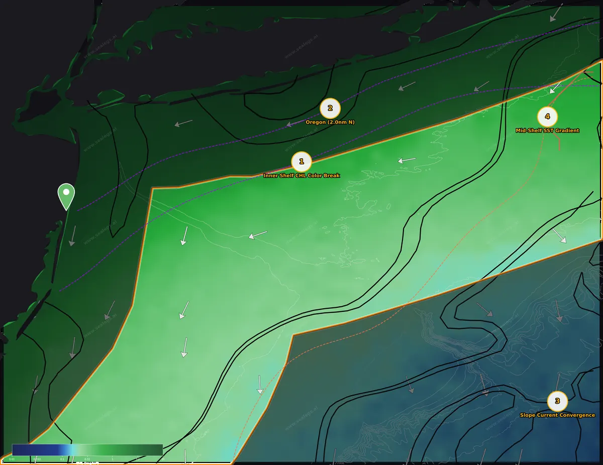
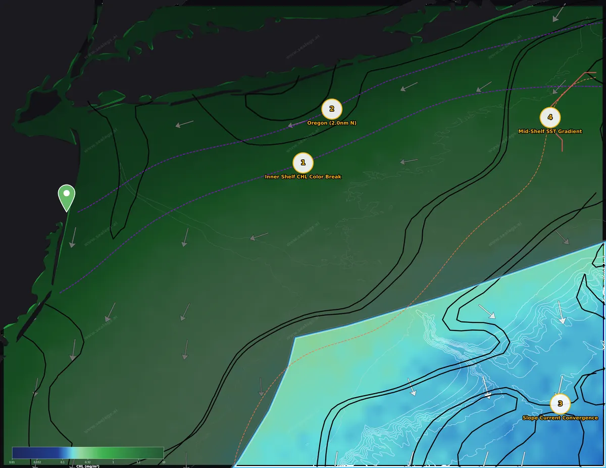
Chlorophyll. Green-to-blue color edges mark where productive water meets clean blue water.
This week's read
The story this week is inshore, not offshore. A well-established green-to-blue color change has been sitting off the Long Island south shore for three straight days, and with Tuesday flat calm inside 20 miles that's where I'd point the bow — a long run east from Manasquan, but the food chain has had time to stack up on it and the wrecks along the same water give you a sea bass fallback. The offshore convergence out past the Hudson is holding the cleanest blue water on the chart and a proper thermocline for bigeye and swords, but Tuesday opens rough out there and a 114-mile run doesn't fit an 11 AM start — make that a Wednesday trip. Being three days past the full moon, expect fish that fed hard overnight; work the first light hours and the mid-afternoon window rather than grinding through midday.
- InshoreGO
- MidshoreCAUTION
- OffshoreCAUTION
Boating calls for Tuesday, Sep 29 from Manasquan Inlet. 3-day board in each zone below.
Inshore (0-20nm)
Tuesday is a GO and the best water inside is the three-day-old color change at the Inner Shelf CHL Color Break, where greener bait-rich water to the north meets cleaner shelf water — that's your bluefish, bonito and false albacore edge. Two miles off the Oregon a second color change lines up with a strong thermal front hugging the beach, giving you a bunker-and-bluefish surface bite with black sea bass on the wreck as the sure thing. Both are long runs east from Manasquan, so leave in the dark and plan on being on the edge by sunrise.
- Tue Sep 29GO
Tuesday is a GO all day. Light 3-5 knot WSW winds and 2.0-2.6ft seas at 7-second periods from the ESE make for smooth, comfortable conditions throughout. Any departure time works for a 12-hour trip.
- Wed Sep 30GO
Wednesday is a GO all day with 93% model confidence. Near-calm morning winds and 2.0-2.1ft seas at 8-second periods from the ESE give way to a gentle 6-8 knot ESE/SSE afternoon breeze. Seas stay organized and comfortable throughout.
- Thu Oct 1CAUTION
Thursday is CAUTION. Mornings are calm with light SSW winds and 2.0-2.3ft seas, but steep wind-wave chop builds from the SSE after noon — reaching 3.3ft at 4-5 second periods with gusts to 19 knots by late afternoon. A 12-hour trip requires an early start and careful monitoring.
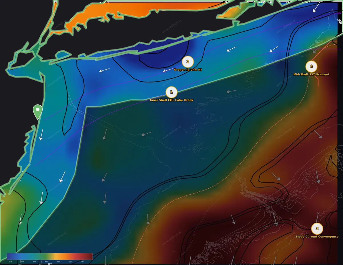
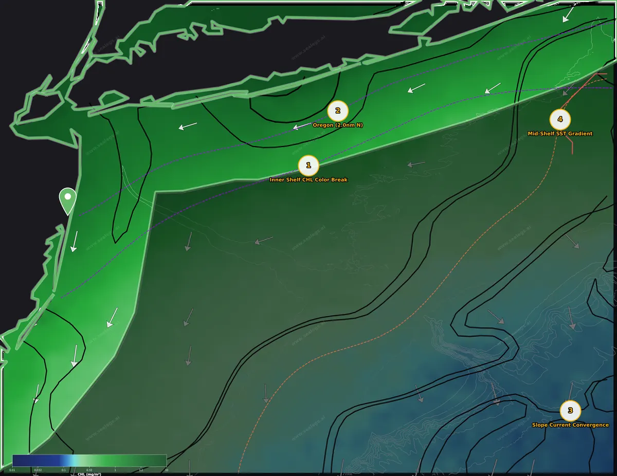
Tuesday is a clean GO inside — 3-5 knot WSW winds and 2-2.5ft ESE seas at 7 seconds mean any departure time works, and Wednesday holds the same. Take advantage of it, because the best surface signals on this chart are inshore off the Long Island south shore, not at the canyons.
The headline is the Inner Shelf CHL Color Break. This color change has held its position for three days — long enough for phytoplankton to draw bait and bait to draw predators. Chlorophyll steps 4.2x across it, from 0.45 mg/m³ on the cleaner south side to 1.88 mg/m³ on the greener north side, spread over about 15nm, so treat it as a zone rather than a hard line. There's no temperature step across it to speak of — the inshore water sits around 66-67°F on average — so this is purely a bait edge. Work it as one: sight-feeding bonito and false albacore will be on the cleaner southern side looking for bunker and peanut bait spilling out of the greener water, while bluefish will push right into the green side in schools. Run the transition east-west with small metals and epoxy jigs ready for surface breaks, and watch for birds. If the surface is quiet, the three wrecks within 10-12nm of the spot sit in the right 60-200ft range for black sea bass — 138ft at the spot itself.
Farther east, Oregon puts you two miles north of the Oregon wreck on a secondary color change that has held for two days. The green/blue ratio is 3.3x (0.91 to 2.98 mg/m³, green side north over about 16nm) — greener overall than the break to the west, which means more bait but less visibility. A strong thermal front from the front analysis hugs the beach just west of here, and the coolest inshore water on the chart (down near 60°F) sits in a pocket along the shore to the north — cool, bait-rich water that suits early-run striped bass and bluefish working bunker schools. Fish the greener side for bluefish, look for striped bass on any bunker pods near the front, and drop on the Oregon itself for black sea bass in 108ft. Bonito are a realistic bonus on the cleaner side.
Moon-wise, Tuesday is three days past the full, and the moon is still 90% lit — fish have been feeding overnight, so the strongest daytime action should come in the first two hours after sunrise and again in the mid-afternoon, roughly 2-4 PM. The tidal currents will still be running harder than average, so bait will be moving well around the inlets on the run out.
Midshore (20-60nm)
The only midshore signal is out on the far east end at the Mid-Shelf SST Gradient, and it's a gradual warming toward the southeast rather than an edge — well-mixed 64°F water that fits fall bluefin, false albacore and bonito, but it's a 102-mile run from Manasquan. Tuesday carries a CAUTION for a confused cross-sea, so if you want to make that trip, Wednesday is the clean GO day. Closer to home the midshore water shows no surface breaks; that's a wreck-and-sea-bass day.
- Tue Sep 29CAUTION
Tuesday carries a CAUTION due to a confused cross-sea — an east swell crossing a NNW wind-wave — creating uncomfortable, multi-directional motion. Winds are light all day, easing to near-calm by evening, with seas gradually dropping from 3.7ft to around 2.6ft. The calmest window is 12:00 PM–6:00 PM, but the cross-sea pattern persists.
- Wed Sep 30GO
Wednesday is a clear GO with light winds under 9 knots WNW and comfortable 2.7–2.9ft seas at 8-second periods from the east all day. No cross-sea issues and any departure time works for a 12-hour trip. Forecast confidence is excellent at 95%.
- Thu Oct 1CAUTION
Thursday is CAUTION with a usable window only from 12:00 AM to 6:00 PM. A confused cross-sea (E swell crossing SW wind-wave) adds discomfort even in the morning, and conditions deteriorate sharply in the afternoon with winds to 20 knots SW and steep 3.9ft seas at 5-second periods by evening. Any trip must wrap up by 6:00 PM.
Tuesday is a CAUTION midshore — winds are light, but an east swell crossing a NNW wind-wave sets up an uncomfortable cross-sea with seas dropping from 3.7ft to about 2.6ft, calmest from noon to 6 PM. Wednesday is the clear GO with WNW winds under 9 knots and 2.7-2.9ft east seas at 8 seconds; if you're going anywhere in this zone, that's the day.
The midshore grounds within a normal run of Manasquan — 30-60nm out over the mid-shelf — show no surface breaks worth running to. Chlorophyll is a fairly uniform 0.19-1.02 mg/m³ and the surface temperature warms gently from about 66 to 71°F toward the shelf edge with no tight edges in between. Weak surface current runs generally southwest along the shelf. That's a day to hit your favorite wrecks and hard bottom for black sea bass, which are in season and stacked in the 60-200ft range.
The one flagged spot is the Mid-Shelf SST Gradient, but understand what it is: a broad warming trend, not a line to troll. The temperature rises 1.8°F toward the east, but that change is spread over about 12nm, so you won't find a hard edge to pull baits along. The water here is cool, about 64.5°F at the surface and essentially the same temperature down to 100ft — thoroughly mixed with no thermocline to hold bait at depth. That kind of cool, well-mixed fall water is exactly what the east-end bluefin fishery is built on as the season turns toward October, and it's also prime false albacore, bonito and bluefish water. Surface current is a modest 0.3 knots to the southwest with slight divergence across the gradient, so don't expect a debris line; find the fish with your eyes and your sounder, working slowly over the gradual warming toward the southeast where the 3.6°F broad regime change sits, and troll small spreader bars or run-and-gun with jigs on surface activity. Wrecks 5 and 9.5nm away are your fallback, though at 216ft the spot itself is a bit deep for comfortable sea bass fishing.
At 102nm from Manasquan this is a long haul for a soft signal — it makes more sense for boats already on the east end, and only on Wednesday's weather.
Offshore (60-150nm)
The Slope Current Convergence is the offshore play — a 1.1 knot pile-up of surface current in the cleanest blue water on the chart, with a sharp thermocline layer between roughly 60 and 155 feet that sets up bigeye above it and swordfish at it. Tuesday is a CAUTION with 5-6ft chop until late morning and a cross-sea all day, which doesn't work for a 114-mile run; Wednesday is the day to make this trip, and the waning moon means the overnight sword bite into first light is where the action should be.
- Tue Sep 29CAUTION
Tuesday opens rough with steep 5-6ft chop before easing after 11:00 AM. The only viable window for a 12-hour trip is 11:00 AM to 9:00 PM, but a confused cross-sea (east swell crossing WNW wind-waves) persists all day, making for an uncomfortable ride regardless of timing.
- Wed Sep 30CAUTION
Wednesday is the standout day with light 6-8 knot northwest winds and 2.8-3.5ft seas at comfortable 7-8 second periods from the east. Any departure time works for a 12-hour trip. A brief cross-sea early in the day is minor and resolves quickly.
- Thu Oct 1CAUTION
Thursday offers a good window from midnight to 9:00 PM, with light-to-moderate southwest winds and 2.8-3.4ft seas in the morning. A confused cross-sea (east swell crossing SW wind-waves) affects the early hours, and conditions turn choppy after 6:00 PM with steep 5-second-period seas. Be off the water before 9:00 PM.
Tuesday is a CAUTION offshore and, practically, a no for a Manasquan boat. Steep 5-6ft chop doesn't ease until after 11 AM, the only viable window is 11 AM to 9 PM, and a confused east-swell-over-WNW-wind-wave cross-sea hangs on all day. At 114nm from the inlet you can't make that window work. Wednesday is the standout — 6-8 knot NW winds, 2.8-3.5ft east seas at 7-8 seconds, any departure time — and Thursday holds a good window until early evening. Plan the offshore trip for Wednesday, or leave Tuesday evening to be on the grounds for the overnight bite once the seas have laid down.
The spot to run to is the Slope Current Convergence, where surface current piles together at 1.1 knots flowing toward the SSW — about 14 miles from the Hudson Canyon over deep slope water. Convergences like this are where floating weed, debris and bait get corralled, and this one sits in the cleanest water on the chart: offshore chlorophyll runs just 0.11-0.21 mg/m³, genuine blue water with the visibility sight-feeding tuna need. The surface here is around 69°F, with the offshore zone topping out near 71.6°F — warm enough for bluefin (the fall canyon run is building) and squarely in the range for bigeye and swordfish, but the surface never quite reaches yellowfin or mahi temperatures, so don't count on them.
The subsurface structure is the real reason to fish here. The warm surface layer holds to about 77ft at 69°F, then the temperature falls fastest between 61 and 155ft, dropping to 60.8°F — 66.7°F at 100ft, 59°F at 200ft, 56°F at 300ft. That steep layer is a barrier where squid and butterfish stack, and it's shallower than the offshore average, a hint of upwelling along the slope. Bigeye hunt just above that barrier: troll the convergence at dawn and dusk with spreader bars and squid-color plugs, and set a chunk drift with butterfish through the evening with baits staged at 60, 100 and 150ft. For swordfish, night drifts with rigged squid at the thermocline depth (100-150ft) are the play, and a daytime deep-drop into the 1000fm+ bottom is a legitimate option while you wait for dark. Keep an eye on the moderate thermal front that runs along the slope west of the convergence — where the SSW current carries surface water across it you may find a rip line with bait.
On the moon: three to four days past full, the fish have been eating at night under a bright moon, so the overnight sword and bigeye bite is the strength of this trip, tapering into a first-light trolling window. Expect a slower midday; save your effort for the mid-afternoon window around 2-4 PM and the evening.
Top spots this week
Ranked by signal strength, how long the feature has held, and how far the run is.
- 1
Inner Shelf CHL Color Break
Inshore · 66.7°F · Bluefish, Bonito (Atlantic), Little tunny (false albacore), Black sea bass
Strongest and most established signal on the chart: a 4.2x green/blue color change (0.45 to 1.88 mg/m³) that has held position for three days, giving bait and predators time to stack up. Tuesday is a clean GO inshore with 3-5 knot winds and 2ft seas. Bluefish, bonito and false albacore on the edge with black sea bass on nearby wrecks as a fallback. Three days past the full moon, be on the edge at sunrise and again for the 2-4 PM window.
- 2
2.0 nm N of Oregon
Inshore · 66.7°F · Bluefish, Striped bass, Bonito (Atlantic), Black sea bass
A two-day-old 3.3x color change (0.91 to 2.98 mg/m³) backed by a strong thermal front along the beach and cool bunker-rich water to the north — a solid bluefish and early striped bass setup with the Oregon wreck two miles away for black sea bass in 108ft. GO weather Tuesday. Ranked behind the western break only because the water is greener and the signal a day younger.
- 3
Slope Current Convergence
Offshore · 69.2°F · Bigeye tuna, Swordfish, Bluefin tuna
The best pelagic water on the chart — a 1.1 knot convergence in clean 0.11-0.21 mg/m³ blue water with a sharp thermocline layer between 61 and 155ft for bigeye and swordfish, and bluefin possible as the fall canyon run builds. Held back by weather: Tuesday's 5-6ft morning chop and all-day cross-sea don't fit a 114nm run. Wednesday's 6-8 knot NW winds and 3ft east seas make it the day, with the waning moon favoring the overnight sword bite into first light.
- 4
Mid-Shelf SST Gradient
Midshore · 64.5°F · Bluefin tuna, Little tunny (false albacore), Bonito (Atlantic), Bluefish
A soft signal — a broad 1.8°F warming spread over 12nm, not a fishable edge — in cool, well-mixed 64.5°F water that suits fall bluefin, false albacore and bonito. It's 102nm from Manasquan under a Tuesday CAUTION cross-sea, so it only makes sense for east-end boats on Wednesday's GO weather. Included as the lone midshore option, not as a reason to run.
Run distances from your inlet
Straight-line distance and heading from each inlet to this week's ranked spots. Plan fuel for the real route, and for the ride home.
From Sandy Hook
This week's #1 spot, Inner Shelf CHL Color Break, is 47 nm E (100°).
From Belmar (Shark River Inlet)
This week's #1 spot, Inner Shelf CHL Color Break, is 48 nm E (080°).
From Manasquan Inlet (Point Pleasant)
This week's #1 spot, Inner Shelf CHL Color Break, is 50 nm ENE (074°). This week's report was run from here.
From Barnegat Inlet (LBI)
This week's #1 spot, Inner Shelf CHL Color Break, is 61 nm NE (056°).
From Beach Haven (Little Egg Inlet)
This week's #1 spot, Inner Shelf CHL Color Break, is 76 nm NE (050°).
From Atlantic City (Absecon Inlet)
This week's #1 spot, Inner Shelf CHL Color Break, is 87 nm NE (049°).
From Fire Island Inlet
This week's #1 spot, Inner Shelf CHL Color Break, is 23 nm SE (141°). The closest ranked spot is #2 2.0 nm N of Oregon, 21 nm E in the inshore zone.
From Moriches Inlet
This week's #1 spot, Inner Shelf CHL Color Break, is 28 nm SSW (202°). The closest ranked spot is #2 2.0 nm N of Oregon, 13 nm SSW in the inshore zone.
From Shinnecock Inlet
This week's #1 spot, Inner Shelf CHL Color Break, is 39 nm SW (217°). The closest ranked spot is #2 2.0 nm N of Oregon, 24 nm SW in the inshore zone.
From Montauk
This week's #1 spot, Inner Shelf CHL Color Break, is 66 nm SW (227°). The closest ranked spot is #4 Mid-Shelf SST Gradient, 33 nm S in the midshore zone.
Today's conditions on the grounds
Live SpotCast forecasts, refreshed every morning, between weekly reports.
Triple Wrecks
The Cigar
Hudson Canyon
About the New Jersey fishing report
This is the weekly New Jersey offshore fishing report from SeaLegs AI. Every week we run a full DeepCast report out of a Jersey inlet and publish it here: satellite sea surface temperature and chlorophyll, the temperature breaks and color edges worth running to, the canyons and wrecks they sit on, and a GO / CAUTION / NO-GO boating call for the inshore, midshore and offshore water.
One report covers the whole Jersey Shore and the south shore of Long Island, from the beach out past the Hudson Canyon. Water moves fast out here. A warm eddy can push a break 20 miles in two days, so treat the spots as where the fish were set up when the satellite passed, and check the live conditions board on this page before you commit to the run.
New Jersey fishing report FAQ
What is the offshore fishing outlook off Manasquan Inlet this week?
The Slope Current Convergence is the offshore play — a 1.1 knot pile-up of surface current in the cleanest blue water on the chart, with a sharp thermocline layer between roughly 60 and 155 feet that sets up bigeye above it and swordfish at it. Tuesday is a CAUTION with 5-6ft chop until late morning and a cross-sea all day, which doesn't work for a 114-mile run; Wednesday is the day to make this trip, and the waning moon means the overnight sword bite into first light is where the action should be.
How is the midshore fishing off Manasquan Inlet this week?
The only midshore signal is out on the far east end at the Mid-Shelf SST Gradient, and it's a gradual warming toward the southeast rather than an edge — well-mixed 64°F water that fits fall bluefin, false albacore and bonito, but it's a 102-mile run from Manasquan. Tuesday carries a CAUTION for a confused cross-sea, so if you want to make that trip, Wednesday is the clean GO day. Closer to home the midshore water shows no surface breaks; that's a wreck-and-sea-bass day.
Where is the best inshore fishing near Manasquan Inlet this week?
Tuesday is a GO and the best water inside is the three-day-old color change at the Inner Shelf CHL Color Break, where greener bait-rich water to the north meets cleaner shelf water — that's your bluefish, bonito and false albacore edge. Two miles off the Oregon a second color change lines up with a strong thermal front hugging the beach, giving you a bunker-and-bluefish surface bite with black sea bass on the wreck as the sure thing. Both are long runs east from Manasquan, so leave in the dark and plan on being on the edge by sunrise.
How far are this week's spots from Sandy Hook, Belmar (Shark River Inlet), Manasquan Inlet (Point Pleasant), Barnegat Inlet (LBI), Beach Haven (Little Egg Inlet), Atlantic City (Absecon Inlet), Fire Island Inlet, Moriches Inlet, Shinnecock Inlet and Montauk?
The run-distance table on this page gives the straight-line distance and heading from each inlet to this week's number one spot and to the closest ranked spot.
How often is the New Jersey fishing report updated?
Every week. Each week SeaLegs AI features one DeepCast report for the New Jersey region, and this page is rebuilt from it. This edition was written for Tuesday, September 29, 2026 out of Manasquan Inlet.
What is DeepCast?
DeepCast is SeaLegs AI's offshore fishing report. It reads satellite sea surface temperature, chlorophyll, currents and bathymetry around your departure port, finds temperature breaks and color edges, ranks the spots worth running to, and pairs them with a GO / CAUTION / NO-GO boating forecast for each zone. You can run one for any port for $4.99.
Get this report for your own inlet
This is one featured DeepCast report a week. In the SeaLegs AI app you can run one out of any port, for any day, whenever you want: temperature breaks, color edges, ranked spots, and a GO / CAUTION / NO-GO call for each zone. $4.99 a report, no subscription.


Decision-support guidance only. Marine weather can change rapidly, and conditions on the water often differ from forecasts. The captain is solely responsible for all go/no-go decisions and must check the official NWS marine forecast and warnings before getting underway. Satellite data: NASA, Copernicus Marine, Open-Meteo, DWD.