AI-Powered Fishing Reports
Get today's offshore fishing report and conditions for your spot. DEEPCAST reads real-time sea surface temperature (SST) breaks, chlorophyll (CHL) edges, eddies, currents, and thermal fronts — and turns them into an AI fishing report with a plain-English weather window for your departure port. Built for recreational and commercial fishermen who need to find productive water fast. Explore the free interactive ocean map in any browser, or get your full report on the go in the app.
Create Your Report Now Explore Free MapWhy Offshore Anglers Struggle
Productive offshore water is hard to find without the right tools. Most anglers are guessing.
Ocean Conditions Change Daily
SST patterns, eddies, and thermal fronts shift constantly. Yesterday's hotspot may be miles away today.
Maps Are Great — Interpretation Is Hard
Ocean maps (including ours) show you what's happening, but knowing which temperature breaks, eddies, and current edges actually hold fish takes years of experience. That's exactly what AI analysis does for you.
Legacy Reports Cost $90+
Other services charge $90 or more per report. DEEPCAST delivers the same ocean analysis at a fraction of the price.
Data Overload, No Interpretation
SST, chlorophyll, currents, eddies, bathymetry, weather — the data is out there, but making sense of it all is the hard part. AI connects the dots across every layer and turns raw data into actionable fishing intelligence.
How DEEPCAST Works
Start with the free ocean map — no account needed. When you want deeper analysis, add an AI report.
Explore the Free Map
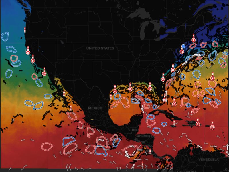
Open the DEEPCAST ocean map anytime to browse live SST, chlorophyll, eddies, currents, and thermal fronts. Always free, no account required.
Browse Free Featured Reports
Curated DEEPCAST reports for top fishing regions, refreshed every week. See real AI analysis directly on the map — no signup required.
Get Your AI Fishing Report
Receive zone-by-zone analysis, annotated SST maps, target species, recommended spots, tactical guidance, and a downloadable PDF — all generated by AI from the latest satellite data.
What's Inside Every DEEPCAST Report
Every report is packed with actionable intelligence — not just raw data.
Annotated SST & Chlorophyll Maps
AI-annotated satellite imagery showing temperature gradients, chlorophyll concentrations, zone boundaries, and current arrows — with key features called out.
Zone-by-Zone Analysis
Inshore (0-20nm), midshore (20-70nm), and offshore (70-100nm+) zones analyzed separately with conditions, structure, and recommendations for each.
Eddies, Fronts & Currents
Every eddy, thermal front, and current pattern in your area is identified and explained — including how they create productive fishing opportunities.
Target Species & Tactics
Species recommendations based on water temperature, season, and structure. Tactical guidance on presentations, depths, and timing.
Recommended Fishing Spots
Specific GPS coordinates for the highest-probability areas based on the intersection of temperature breaks, structure, and current convergence zones.
Downloadable PDF
Every report comes as a printable PDF you can take offshore — complete with maps, analysis, and recommendations. No cell signal required.
See a DEEPCAST Report in Action
Preview a real AI-generated fishing report — complete with zone analysis, annotated maps, weather assessment, and recommended spots.
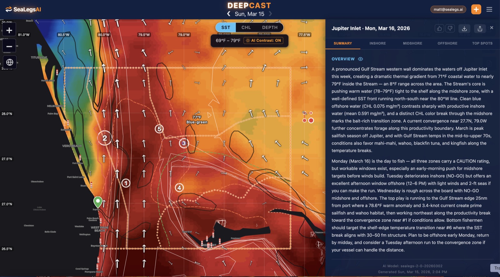 View Sample Analysis
Free Interactive Ocean Map — Always Free, No Account Required
The DEEPCAST ocean map is 100% free to use, no account or purchase needed. Explore live SST, chlorophyll, eddies, currents, thermal fronts, and depth contours — updated daily. Use it on its own to scout conditions, or pair it with an AI-generated report for deeper analysis.
 Open the Free Map
Simple, Transparent Pricing
The ocean map and weekly Featured Reports are always free. Reports for your own area and date are a fraction of what legacy services charge.
The full interactive ocean map plus weekly Featured Reports — real DEEPCAST AI analysis for top fishing regions, refreshed every week.
- SST, chlorophyll, eddies, currents, thermal fronts, bathymetry
- Weekly Featured Reports for top regions
- Zone-by-zone AI analysis included
- No account, no credit card
One AI fishing report for your departure port. Perfect for occasional trips.
- Zone-by-zone analysis
- Annotated SST & chlorophyll maps
- Target species & tactics
- Downloadable PDF
10 DEEPCAST reports. Best for active offshore anglers.
- 10 AI fishing reports
- Any departure port, any region
- Credits never expire
- Save 20% vs single reports
Built For Serious Offshore Anglers
Tournament Anglers
Scout conditions on the free map and gain an edge with AI reports that show you exactly where the productive water is before your competitors do.
Charter Captains
Check the free map daily and use AI reports to put your clients on fish consistently with zone-by-zone analysis and tactical guidance.
Recreational Offshore
Browse the free ocean map anytime to check SST and currents. When you're ready to plan a trip, an AI report tells you exactly where to go.
Commercial Fishing
Monitor ocean conditions daily on the free map. Use AI reports to optimize fuel costs and target verified productive zones.
Coverage Areas
Free ocean charts. AI fishing reports. Available across major offshore fishing regions worldwide.
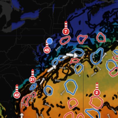
US East Coast
Gulf Stream eddies, warm-core rings, and temperature breaks for tuna, marlin, and mahi-mahi.
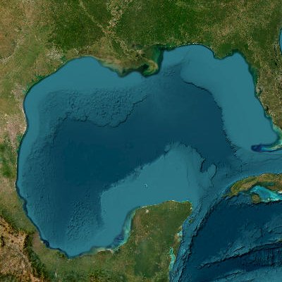
Gulf of Mexico
Loop Current eddies and thermal fronts for yellowfin tuna, bluefin tuna, and wahoo.
US West Coast
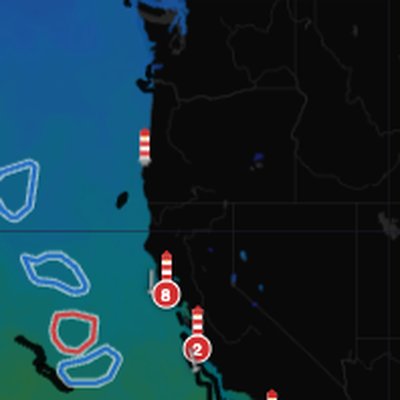
California Current eddies and upwelling zones for albacore, yellowfin tuna, and dorado.
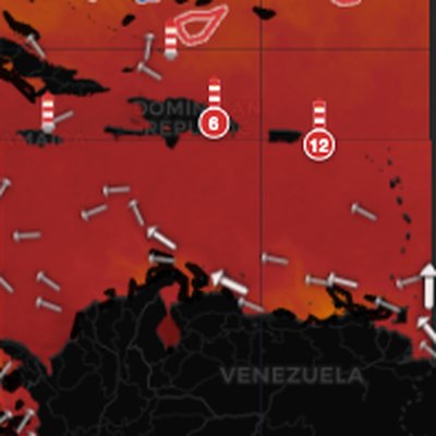
Caribbean
Warm-water pelagic zones for blue marlin, wahoo, yellowfin tuna, and mahi-mahi.
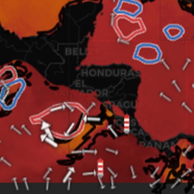
Central America
Pacific offshore waters for roosterfish, yellowfin tuna, sailfish, and dorado.
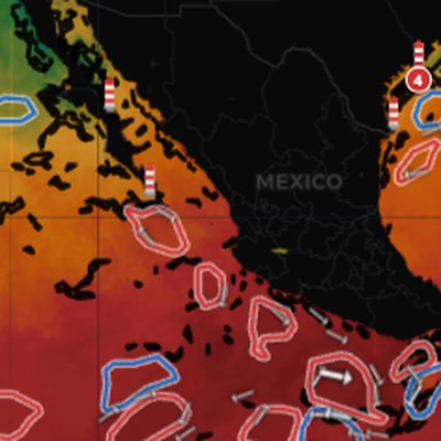
Mexico
Baja and Pacific coast waters for yellowfin tuna, dorado, striped marlin, and wahoo.
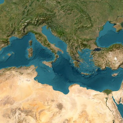
Mediterranean
Bluefin tuna grounds, Sicily Channel fronts, and Aegean thermal breaks for swordfish, albacore, and amberjack.
Don't see your region? We're always expanding. Let us know where you fish and we'll prioritize it: support@sealegs.ai
Frequently Asked Questions
What is DEEPCAST?
DEEPCAST is two things: a free interactive ocean map and optional AI-generated fishing reports. The map shows live SST, chlorophyll, eddies, currents, and thermal fronts — always free, no account needed. The AI reports go further, analyzing all that data plus weather to give you zone-by-zone fishing recommendations, target species, and tactical guidance for your departure port.
Is the ocean map really free?
Yes — the DEEPCAST map is 100% free, no account, no purchase, no strings attached. You can use it every day without ever buying a report. It shows live SST tiles, chlorophyll-a, ocean eddies with contours, surface currents, thermal fronts, depth contours, and water color labels — all updated daily. Visit sealegs.ai/deepcast/map to explore.
Why would I buy a report if the map is free?
The map shows you the raw ocean data — but interpreting SST gradients, eddy edges, current interactions, and weather windows all at once takes real expertise. The AI report does that interpretation for you: it analyzes every data layer together, factors in weather conditions, and delivers plain-English recommendations on where to fish, what to target, and when to go.
How is DEEPCAST different from traditional SST chart services?
Traditional services give you raw satellite imagery that requires expert interpretation and charge $50-100+. DEEPCAST starts with a free map anyone can use, then offers AI reports that analyze all the data layers together — including weather assessments — and produce actionable fishing plans with specific recommendations, starting at $4.99.
What data sources does DEEPCAST use?
DEEPCAST combines satellite SST imagery (NOAA, Copernicus), satellite altimetry for eddy detection, CMEMS ocean current models, chlorophyll-a concentration data, ETOPO bathymetry, and NOAA weather forecasts. The free map visualizes these data layers directly. The AI reports process all of them together to generate fishing intelligence.
How much does an AI report cost?
Featured Reports are free on the map — refreshed weekly for top fishing regions, no signup required. To run a report for your own area and date, a single report is $4.99 — about the price of a cup of coffee. The 10-Pack is $39.99 ($3.99/report). No subscription required — credits never expire. The ocean map is always free regardless.
What area does each report cover?
Each report analyzes a 150-nautical-mile radius from your selected departure port, divided into three zones: inshore (0-20nm), midshore (20-70nm), and offshore (70-100nm+). The AI identifies productive features across all zones and integrates weather conditions for each.
What is the best SST chart for offshore fishing?
The best SST chart for offshore fishing combines sea surface temperature with other data layers — chlorophyll, ocean eddies, currents, and bathymetry — so you can see the full picture. The DEEPCAST ocean map does exactly that, showing all these layers together in one free interactive chart updated daily. When you need help interpreting it, our AI reports analyze everything and tell you where to fish.
How do ocean eddies help you find fish?
Ocean eddies are rotating bodies of water that break off from major currents like the Gulf Stream and Loop Current. Warm-core eddies trap warm, nutrient-rich water that concentrates baitfish — which draws pelagic game fish like tuna, marlin, mahi-mahi, and wahoo to the eddy edges and thermal boundaries. DEEPCAST tracks every eddy in your region and the AI reports identify which ones are most productive for fishing. Learn more in our Ocean Eddy Fishing Guide.
Do I need to download an app to use DEEPCAST?
No — DEEPCAST works entirely in your browser. The free ocean map and AI fishing reports are all accessible from any device with no app download, no account, and no sign-up required. Just open the map and start exploring.
How does DEEPCAST compare to ROFFS and other satellite fishing services?
Services like ROFFS provide expert-interpreted satellite fishing reports starting around $90+ per report. DEEPCAST takes a different approach: a free interactive ocean map with SST, chlorophyll, eddies, currents, and depth contours — available to everyone, no purchase required. Featured Reports refresh weekly on the map so you can see real AI analysis before paying. Reports for your own area and date are $4.99 — about the price of a cup of coffee — with zone-by-zone recommendations, target species, tactical guidance, and a downloadable PDF.
Free Ocean Maps + Weekly Featured DEEPCAST Reports
Browse SST, chlorophyll, eddies, currents, thermal fronts, and bathymetry — plus weekly AI Featured Reports for top fishing regions, all free on the interactive map. When you want a report for your own spot and date, run one for $4.99 — about the price of a cup of coffee. Zone analysis, annotated SST maps, target species, and tactical guidance included.
Open the Map