Destin Marine Forecast
Updated Mon Sep 14, 2026
Calm Mon-Tue boating, Wed gusty afternoon chop
Drop a pin on any spot in the world — free in the SeaLegs AI app.


Marine Forecast for Destin, FL Sep 14–16, 2026
📋 Calm Mon-Tue boating, Wed gusty afternoon chop
A great day on the water with light 1-5 knots northwest winds (gusts to 12 knots) and small 0.6-0.9 feet seas at 3-second periods from the southwest. Visibility is excellent all day, making any hour a good time to head out.
Another favorable day with gentle 2-6 knots east-northeast winds (gusts to 15 knots) and modest 0.6-0.8 feet seas at 4-second periods from the south. Clear visibility and calm seas all day keep this a solid, comfortable outing.
Use caution: winds pick up to 4-10 knots east-northeast with gusts to 22 knots, and seas build to 1.1-2.3 feet at a short 3-second period from the east-southeast, creating a steeper, choppier ride. Confidence is lower too, so plan carefully and stay alert to changing conditions.
Monday 12:00 AM to 11:00 AM is the top pick, with light 1-5 knots northwest winds and gentle 0.6-0.9 feet seas at 3-second periods from the southwest making for easy, comfortable conditions.
Recent days at Destin, FL
Today’s Water at Destin Pass
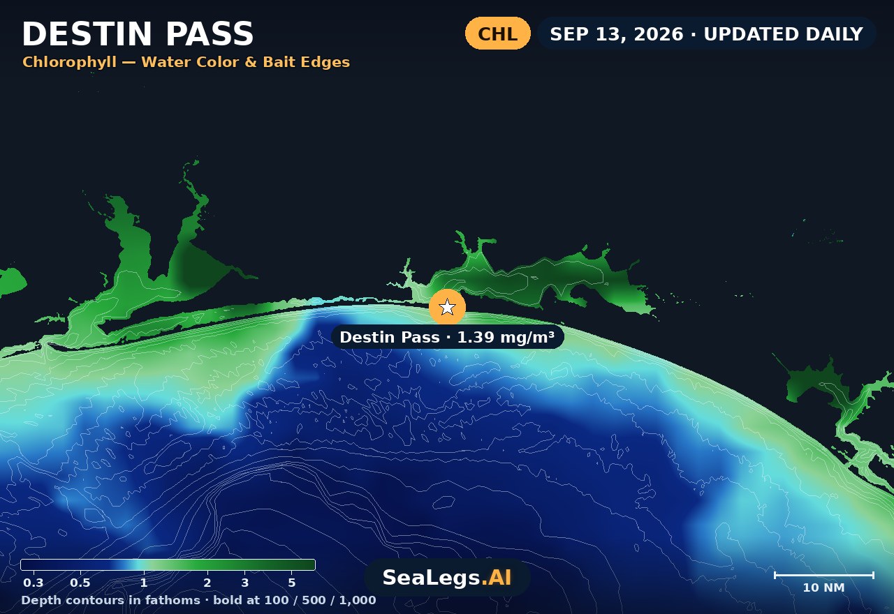
Sea surface temperature and chlorophyll around Destin Pass, imaged fresh every morning. Water at the star is 85.6°F today, and chlorophyll of 1.39 mg/m³ reads as nutrient-rich green water at the spot.
Imagery: Sep 13, 2026 · rebuilt every morning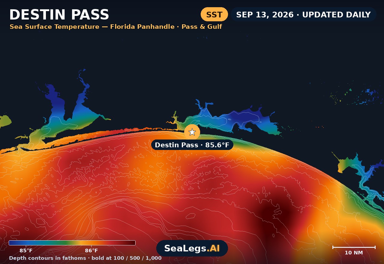
These charts show you the breaks. DeepCast reads them. A zone-by-zone AI fishing report for these exact waters — temperature edges, color changes, and structure, analyzed together — for $4.99.
Get the AI fishing reportSST and chlorophyll from the SeaLegs AI DeepCast satellite pipeline. Charts are a planning aid — always check the official marine forecast before making the run.
About Destin
Destin sends its whole fleet through one gate: Destin Pass, the East Pass cut between Holiday Isle and Santa Rosa Island. The charter boats, the party boats, the private boats out of Destin Harbor and everyone coming down from Choctawhatchee Bay cross it on the way out and again on the way home. That is why a Panhandle-wide forecast is not much use here, and a read on this water is.
The outlook below updates every morning from the latest marine model data, and each day gets a plain GO, CAUTION, or NO-GO call, the same AI rating used in the SeaLegs AI app.
Reading conditions at Destin
Read the pass first. This is Choctawhatchee Bay's only direct outlet to the Gulf, so a large body of water squeezes through one narrow, shoaling channel on every tide. When a strong ebb runs out against a southerly swell or an onshore breeze, the sea stands up short and steep in the cut, and the same morning can be rough in the pass and perfectly workable a mile outside it. Time the run with the tide, not just the wind.
Then read the distance you are running. The shelf off Destin is flat and shallow for a long way: under 90 feet of water ten nautical miles out, about 105 feet at fifteen, then 174 feet at twenty and nearly 400 at thirty. The nearshore reefs and wrecks are a short hop; the shelf break around twenty to twenty-five nautical miles and the blue water past it are a real commitment. For the open Gulf beyond, see the Gulf of Mexico offshore forecast.
Headed out on a party boat? The captain decides whether the trip runs, and a trip that is safe to run is not always a comfortable one. The number that tells you how the day will feel is wave period as much as height: short-period wind chop at a few seconds pitches a boat far harder than a longer, rolling swell of the same size, and on a four- or six-hour bottom-fishing trip you spend most of it drifting over the reef, feeling every one. If the card above says CAUTION, pick the steadier day if you can, eat light, and take any seasickness medicine the night before and again in the morning rather than once you are already out there.
Then watch the season. Summer here runs on the sea breeze and afternoon thunderstorms, so mornings are usually the flattest water of the day. From October the first cold fronts arrive, turning the Gulf rough for a few days and then handing back glassy post-frontal mornings. Hurricane season runs through November 30. This page is a planning aid, not a substitute for the official NWS coastal waters forecast and marine warnings.
Destin, FL forecast FAQ
How is the sea at Destin, FL today?
As of Sep 14, 2026, the SeaLegs AI verdict for Destin, FL is GO. A great day on the water with light 1-5 knots northwest winds (gusts to 12 knots) and small 0.6-0.9 feet seas at 3-second periods from the southwest. Visibility is excellent all day, making any hour a good time to head out.
What marine forecast zone covers Destin?
Destin Pass sits in NOAA zone GMZ655, coastal waters from the Okaloosa-Walton County Line to Pensacola out 20 nautical miles, issued by the National Weather Service in Mobile. Water from 20 to 60 nautical miles out is GMZ675. The forecast on this page is built for Destin Pass itself rather than the whole zone, so it reflects the water every boat crosses leaving and returning.
Why is Destin Pass rougher than the Gulf outside it?
Choctawhatchee Bay drains to the Gulf through this one narrow, shoaling channel, so the tidal current through it is strong. When that current runs against the wind or an incoming swell, the waves in the cut become short and steep, noticeably worse than the water a mile offshore. A falling tide against a southerly breeze is the classic bad ride home.
Will my Destin party boat trip go out if it is rough?
That call belongs to the captain, so check with your boat. What this page adds is how the trip is likely to feel. A GO day is comfortable for most people; on a CAUTION day expect a lively ride, and weigh the wave period as well as the height, because short, steep chop is what makes people seasick on a boat that spends hours drifting over the reef.
How far offshore is the deep water at Destin?
Further than the local reputation suggests. Along the run south-southwest from the pass, the bottom is under 90 feet ten nautical miles out and about 105 feet at fifteen; the shelf break comes at roughly twenty to twenty-five nautical miles, and the 100-fathom curve a little past forty.
How often is this Destin forecast updated?
The forecast is rebuilt every morning from the latest marine model data, and the SpotCast card refreshes live in your browser. The date stamp above the outlook shows exactly when it was last generated.
What do GO, CAUTION, and NO-GO mean?
GO means conditions are favorable for most recreational boats. CAUTION means marginal, manageable for experienced crews in capable vessels, but check the wind, the wave period and the state of the tide closely. NO-GO means conditions are hazardous for small craft and the trip is best postponed.
Can I get a forecast like this for my own spot?
Yes. In the free SeaLegs AI app you can drop a pin on any spot on Earth, from a reef numbers pair to a wreck past the shelf break, and get the same AI-rated marine forecast, plus fishing reports and trip planning.
What is the water temperature at Destin Pass today?
As of Sep 13, 2026, the satellite-derived sea surface temperature at Destin Pass is about 85.6°F, with chlorophyll around 1.39 mg/m³ (nutrient-rich green water). The SST and chlorophyll charts on this page are rebuilt every morning from the SeaLegs AI DeepCast satellite pipeline.
More offshore forecasts
Get this forecast for your own spot
Drop a pin on any spot on planet Earth in the free SeaLegs AI app — AI marine forecasts, fishing reports, and trip planning, rated GO / CAUTION / NO-GO.
📍 Get a Marine Forecast Near You →or download directly: