Destin Offshore Fishing ReportWeek of Sep 14 · out of Destin Pass
Weekly report · published Wednesday, September 16, 2026
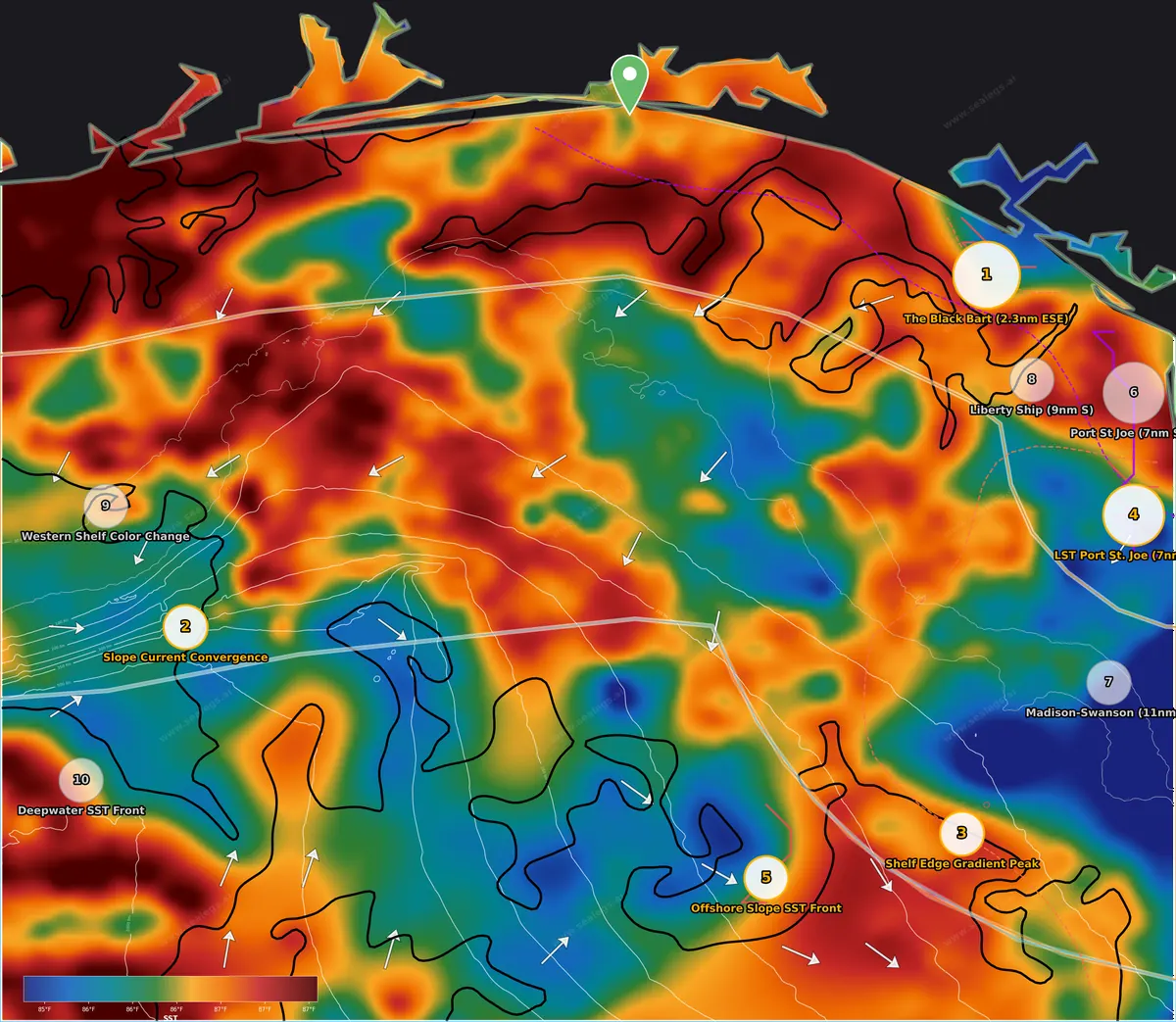
Sea surface temperature. Warm-to-cool breaks are where bait and pelagics stack.
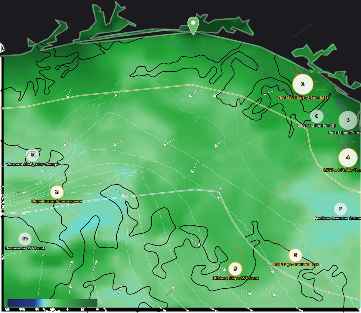
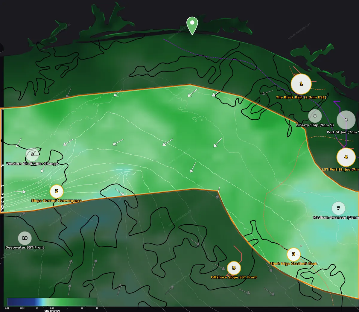
Chlorophyll. Green-to-blue color edges mark where productive water meets clean blue water.
This week's read
The best water this week sits well east of Destin off Panama City and St. Joe, where a strong green-to-blue color edge runs right over the Black Bart wreck complex and has held there for three straight days. Thursday is the problem: the midshore and offshore are blown out on a steep east chop, and even the inshore run only opens after about 2 PM. If you go Thursday, it is an afternoon-into-evening inshore trip for tarpon and grouper on the wrecks east of St. Andrews Pass, timed to the evening feeding window. Friday is the full inshore day, and Saturday is when the shelf edge and slope finally open up for blue marlin and deep-drop work at the current convergence over the slope and the temperature break on the shelf edge south of St. Joe.
- InshoreCAUTION
- MidshoreNO-GO
- OffshoreNO-GO
Boating calls for Thursday, Sep 17 from Destin Pass. 3-day board in each zone below.
Inshore (0-20nm)
The Black Bart wreck area is the inshore play. A green shelf-water edge has pushed over the wrecks 2 to 4 miles outside St. Andrews Pass and held for three days, stacking bait over structure that already holds grouper and snapper, with tarpon working the pass mouth. Thursday is a CAUTION day that only opens after 2 PM, so it is a late run timed to the evening bite; Friday is a full GO and the better day to make the 43-mile run east.
- Thu Sep 17CAUTION
Thursday is NO-GO until 2:00 PM CDT due to choppy 3.5-3.7ft seas at short 4-second periods from the ESE. Conditions ease from 2:00 PM onward, opening the only viable window for a 12-hour trip. Light winds throughout, but the morning wave chop is the key concern.
- Fri Sep 18GO
Friday is a full GO with light 3-6 knot winds and seas easing from 2.4ft in the morning to 1.6ft by evening, all at 4-second periods from the SE/SSE. Every hour rates good — maximum flexibility for a 12-hour trip. The highest-confidence day of the forecast at 83%.
- Sat Sep 19GO
Saturday is GO with the 12-hour trip window opening at 2:00 PM CDT. Winds are near-calm all day and seas stay under 1.5ft at 4-second periods from the SSE, though afternoon gusts spike to 16-22 knots from the south between 2:00 PM and 5:00 PM. Moderate confidence at 70% — monitor updates for the afternoon gust forecast.
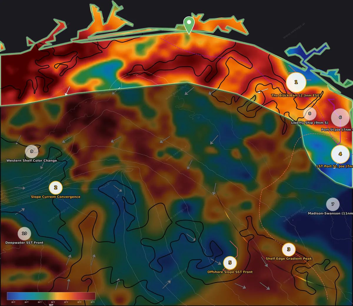
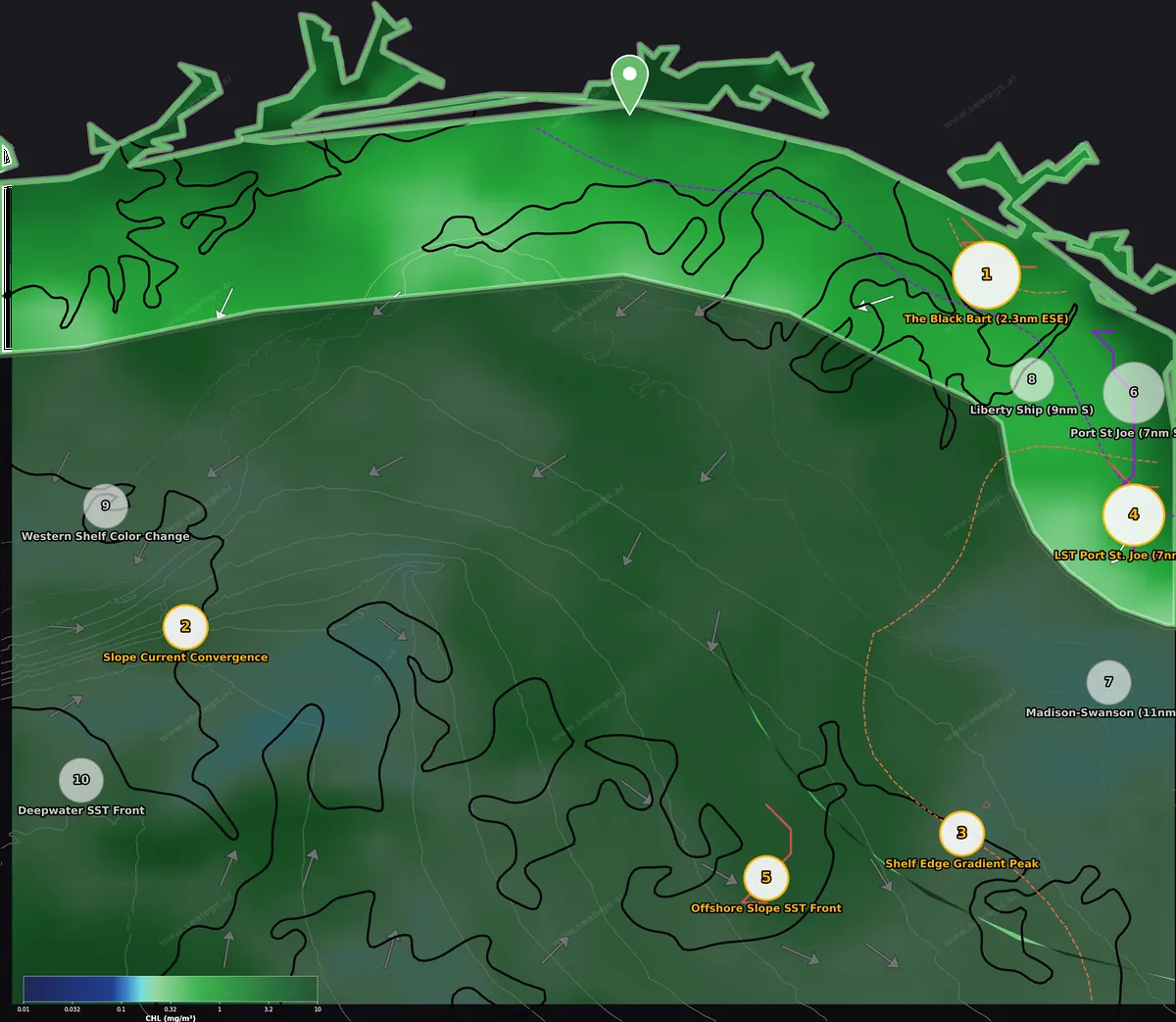
Thursday weather: CAUTION — NO-GO until about 2 PM, then fishable. Morning brings a short, choppy 3.5 ft ESE sea that will beat you up on the 43-plus-mile run east. From 2 PM on the chop lays down and light winds hold, so the realistic Thursday plan is a late departure, an evening bite, and a run home in the dark. Friday is a full GO with 3-6 knot winds and seas easing to under 2 ft — the better day for the inshore program. Saturday is also GO.
The story inshore is the green shelf water east of the port. The whole eastern half of the inshore zone off Panama City and St. Joe is carrying productive water (inshore CHL runs 0.28 to 13.3 mg/m³ against a midshore mean of 0.35), and the edge where that green water meets cleaner shelf water has set up right over the best wreck structure in the area.
The Black Bart is the top inshore spot. The spot sits 2.3 miles ESE of the Black Bart and 3.9 miles WNW of the USS Strength, about 4.8 miles SSW of St. Andrews Pass, with a wreck 0.8 miles off, another at 1.4 miles, and an obstruction at 1.4 miles. A 5.5x green-to-blue color break (0.48 → 2.63 mg/m³, about 11 miles wide) crosses this wreck field, and there is a modest 0.8°F temperature change across it with the warmer water to the south — a color change more than a true break. What makes it the pick is persistence: this edge has held here for 3 days, long enough for bait to load onto the wrecks. In 78 ft of 85.8°F water, fish live bait or cut bait on the bottom for red grouper and mangrove snapper, and work gray triggerfish on the hard structure (check the current triggerfish season before keeping any). With the pass this close and the water this warm, tarpon are still moving along the beach in September — run a live gulf menhaden or threadfin herring under a float while the bottom rods soak. Thursday's peak feeding window is 5 to 7 PM, which is exactly when you will be on the wrecks after a 2 PM departure; on Friday, be there by first light and fish through the morning.
LST Port St. Joe sits 7 miles SSE of the LST Port St. Joe wreck in 66 ft, with another wreck 6.9 miles away. This is the sharpest color edge in the inshore zone — a 3.0x green-to-blue CHL front with the productive water on the east side toward Cape San Blas, and a weak 0.8°F step with warmer water to the northeast. The edge appeared yesterday and is holding. Bait stacks on the green eastern side; work the edge itself with live threadfin herring for tarpon along the beach side, and drop cut bait on the nearby wreck for red grouper. At 73 miles from Destin this is a long run for a Thursday afternoon window — save it for Friday.
Liberty Ship is 9 miles south of the Liberty Ship in 84 ft of 86.7°F water with an obstruction 2.5 miles away. The 4.4x color break here (0.40 → 1.78 mg/m³) is spread over 14 miles, so treat it as a gradual greening toward shore rather than a hard line. Worth a stop for mangrove snapper on the obstruction and a look for rolling tarpon on the way to the Black Bart, but it is not a destination on its own.
Port St Joe lies 7 miles SW of Port St. Joe in only 30 ft, where a 5.1 mg/m³ CHL hotspot sits tight to the beach. Water this green this close to shore in September is more likely stirred sediment than clean bait water, so keep expectations modest. The two obstructions within 1.7 miles will hold sheepshead and mangrove snapper — a Friday or Saturday option when the beach lays down flat.
Skip red snapper — the federal season is closed in September for most private anglers; check current state and federal regulations before keeping anything.
Midshore (20-60nm)
Thursday is a hard NO-GO across the midshore on 5 ft east seas and 20-knot winds; Friday only opens after 1 PM and Saturday is the real day. When it lays down, the current convergence over the slope southwest of the port has held two days and is the blue marlin and daytime swordfish play, while a 1.7°F temperature step on the shelf edge south of St. Joe sets up marlin trolling over golden tilefish bottom.
- Thu Sep 17NO-GO
Thursday is a NO-GO with rough 4.5-5.5ft seas at choppy 5-second periods from the east and ENE winds up to 20 knots gusting to 26 knots. Conditions ease late evening but not enough for a 12-hour trip. No viable departure window exists today.
- Fri Sep 18CAUTION
Friday is CAUTION — a 12-hour trip works only if you depart at 1:00 PM or later. Morning sees choppy 3.3-3.5ft seas at 4-second periods with east winds gusting to 21 knots. Conditions improve significantly by afternoon with light winds and easing seas through midnight.
- Sat Sep 19GO
Saturday is a GO with light 3-7 knot northwest winds and small 1.0-2.2ft seas at 4-5 second periods from the southeast all day. Any departure time works for a 12-hour trip. Note that gust forecasts show some model spread, so occasional puffs up to 20+ knots are possible.
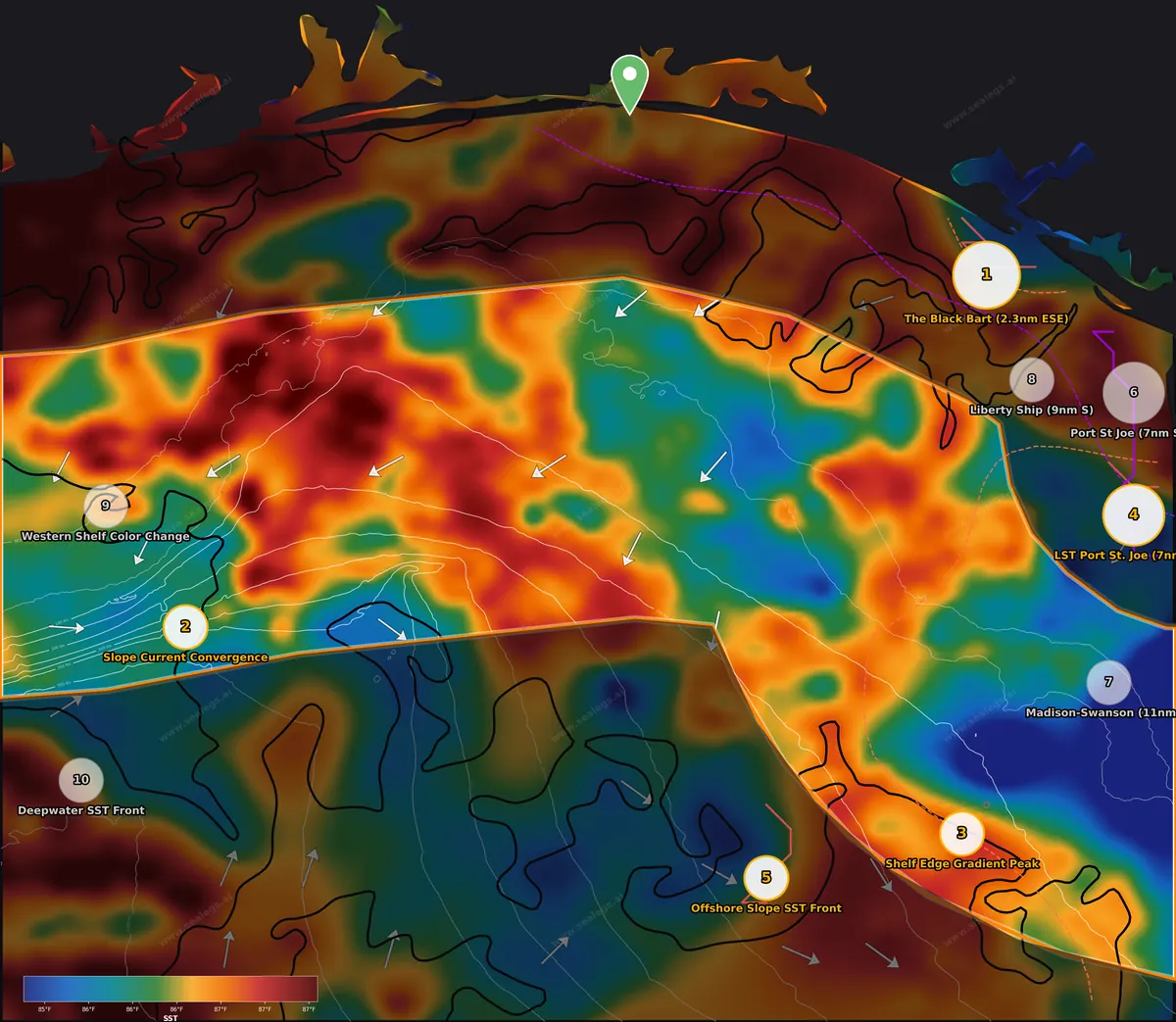
Thursday weather: NO-GO. Rough 4.5-5.5 ft seas at 5-second periods from the east with ENE winds to 20 knots gusting 26 — no viable window for a midshore run. Friday is CAUTION with a 1 PM-or-later departure only. Saturday is the fallback: full GO with 3-7 knot NW winds and 1-2 ft seas all day. Plan the midshore trip for Saturday.
The midshore is bluer than it looks from the dock — CHL runs 0.18 to 0.83 mg/m³ with a mean of 0.35, clean pelagic water with only faint shading. Surface flow across the middle of the zone trends steadily to the southwest, pushing shelf water out toward the slope, and where that flow meets the slope is where the action concentrates.
Slope Current Convergence is the midshore headliner for Saturday. At 326 fm (roughly 1,950 ft) southwest of the port, surface currents pile up here at 0.3 kts with a component setting east, and the convergence has held for 2 days — long enough to gather flotsam, flying fish and blue runner along a debris line. This is a pure pelagic feature with no depth relevance beyond the fact that it sits over marlin water. The warm layer runs to 76 ft at 84.9°F, with the steepest temperature drop from 61 to 155 ft down to 78.2°F, so troll for blue marlin in the upper layer with ballyhoo and pitch a live blue runner when one shows. Deep water at 500 ft reads 61.7°F — swordfish temperature — so bring the deep-drop gear and work rigged shortfin squid or bonito belly strips on the bottom through midday on the slightly shallower side of the convergence. Saturday's midday-to-mid-afternoon moonrise window around 2-3 PM is a reasonable time to be on the deep-drop; the main feeding push comes later in the evening after 6:30 PM, so plan to troll the convergence line through late afternoon on the way home.
Shelf Edge Gradient Peak south of St. Joe sits at 110 fm (660 ft) on the shelf edge where a broad temperature regime change crosses the drop-off with a 1.7°F step across the steepest section, warmer water to the southwest, and a light 0.2 kt current setting SSE across the contour. The change has held for a day. Current crossing the shelf edge with a temperature step on it is a classic bait-stacking setup — troll the warm side for blue marlin along the edge, and at 660 ft the bottom is right at the top of golden tilefish depth for a deep-drop between trolling passes. Warm layer here holds to 66 ft, with the steepest drop 61-155 ft down to 75.9°F.
Madison-Swanson sits 11 miles east of the Madison-Swanson closed area (stay outside the reserve boundary) in 198 ft of 85.2°F water with a wreck 6.5 miles off. A 1.1°F break with 3-mile-wide transition runs through here, warmer water to the northwest, with a weak 0.2 kt current setting WSW. A modest surface edge, but on this bottom it points you to productive live-bottom fishing: vermilion snapper, scamp grouper and red grouper on the ledges and the wreck. At 86 miles from Destin it is a long Saturday run — pair it with the shelf edge spot to the west.
Western Shelf Color Change west of the port sits in 180 ft with a wreck 3.0 miles away. A gradual 1.1°F step spread over 6 miles crosses the area with a 0.4 kt SW current — worth a look but not an edge to troll. The value is the wreck: vermilion snapper and greater amberjack (verify the current amberjack season before keeping any) on live cigar minnows.
Offshore (60-150nm)
Offshore is NO-GO Thursday and only marginal through the weekend, with Saturday the first look at a window and low confidence at that. When it settles, the 1.3°F temperature break on the slope with converging current running across it, south-southeast of the port, is the blue marlin spot, with golden tilefish bottom underneath for the deep-drop.
- Thu Sep 17NO-GO
Thursday is a no-go all day. Seas of 4.8-5.8 feet at 5-second periods from the east are steep and choppy, with ENE winds 15-18 knots gusting to 25 knots. No window exists for a 12-hour trip.
- Fri Sep 18CAUTION
Friday requires patience — conditions are no-go until 4:00 PM. After 4:00 PM, seas ease to 3.0-3.5 feet at 4-second periods from the east with winds dropping to 7-10 knots ENE, opening the only viable 12-hour window of the day.
- Sat Sep 19CAUTION
Saturday looks favorable with near-calm winds and seas easing to 1.4-2.0 feet, but forecast confidence is low at 57% — models disagree on wind behavior. Best window is 8:00 AM to noon; verify the forecast before departing.
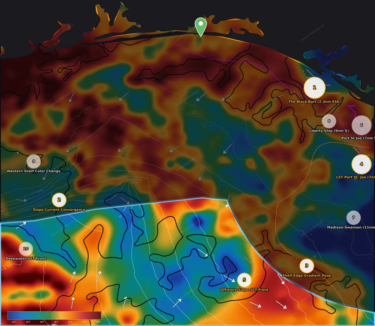
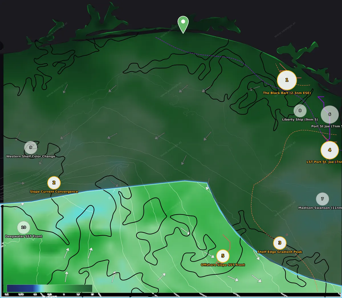
Thursday weather: NO-GO all day — steep 4.8-5.8 ft east seas with ENE winds 15-18 gusting 25, no window for a 12-hour trip. Friday is NO-GO until 4 PM, which makes it a non-starter for a 95-100 mile run. Saturday is CAUTION with near-calm winds and 1.4-2 ft seas forecast, but confidence is only 57% and the recommended window is 8 AM to noon — verify the forecast the night before and be honest about turning around.
The offshore water is clean and warm (CHL mean 0.39 mg/m³, SST 85.3 to 87.6°F), and the deep slope is carved up by a series of moderate temperature changes. Surface currents run to the north and northeast over the western slope and swing to the southeast over the eastern slope, so the flow is doing different things on either side of the zone.
Offshore Slope SST Front is the pick when the offshore opens. In 177 fm (about 1,060 ft) south-southeast of the port, a 1.3°F break with a 5-mile-wide transition runs through here with the warmer water to the east, and a 0.6 kt current setting SE pushes across the line — the flow is convergent at the break, which is what makes it more than a modest temperature line. Current piling into a temperature edge concentrates flying fish and blue runner, and 86.2°F water with a warm layer to 76 ft is blue marlin water: troll ballyhoo and blue runner along the warm eastern side of the break and bump across it. The steepest temperature drop runs 61-155 ft down to 76.4°F. The bottom at 1,060 ft is squarely in golden tilefish depth for a midday deep-drop between trolling passes.
Deepwater SST Front sits far to the southwest in 873 fm (over 5,000 ft) of 86.4°F water, 100 miles from Destin. A 1.3°F break with a tight 3-mile transition and warmer water to the southwest runs here, with a 0.5 kt current setting NE across it — also convergent. It is a good blue marlin edge in its own right, but at this range with the current forecast uncertainty it is a stretch; if the Saturday window firms up and you are already committed to the western slope, troll the warm SW side. There is nothing here for the bottom rods — the water is far too deep.
Top spots this week
Ranked by signal strength, how long the feature has held, and how far the run is.
- 1
2.3 nm ESE of The Black Bart
Inshore · 85.8°F · Tarpon, red grouper, mangrove snapper, gray triggerfish
Strongest convergence of signals in fishable water: a 5.5x green/blue color break over a wreck field 2.3nm ESE of the Black Bart, held for 3 days so bait has loaded onto the structure. Only zone that opens Thursday (CAUTION, after 2 PM) with the 5-7 PM peak feeding window landing right on arrival; Friday is a full GO for a proper day on the grouper, snapper and tarpon.
- 2
Slope Current Convergence
Midshore · 86.4°F · Blue marlin, swordfish
NO-GO Thursday on 5 ft east seas — run it Saturday when the midshore is a full GO. A 2-day current convergence over the slope gathers a debris line for blue marlin trolling in the warm layer, with 61.7°F water at 500 ft for daytime swordfish deep-drops beneath it.
- 3
Shelf Edge Gradient Peak
Midshore · 86.4°F · Blue marlin, golden tilefish
NO-GO Thursday; Saturday GO. A 1.7°F step with current setting across the shelf edge at 660 ft — temperature change plus flow plus structure — held since yesterday. Blue marlin on the warm side and golden tilefish on the bottom in one stop.
- 4
7 nm SSE of LST Port St. Joe
Inshore · 86.1°F · Tarpon, red grouper
The sharpest color edge in the report — a 3.0x green/blue CHL front with bait on the eastern side, holding since yesterday, near a wreck for red grouper and beach-edge tarpon. Inshore GO on Friday; the 73nm run is too long for Thursday's afternoon-only window.
- 5
Offshore Slope SST Front
Offshore · 86.2°F · Blue marlin, golden tilefish
NO-GO Thursday and Friday, marginal low-confidence CAUTION Saturday morning — verify before running. A 1.3°F break with 0.6 kt convergent current piling across it in 86°F marlin water, over golden tilefish bottom at 1,060 ft; the best pure pelagic edge offshore once the seas settle.
Run distances from your inlet
Straight-line distance and heading from each inlet to this week's ranked spots. Plan fuel for the real route, and for the ride home.
From Orange Beach (Perdido Pass)
This week's #1 spot, 2.3 nm ESE of The Black Bart, is 93 nm E (098°). The closest ranked spot is #2 Slope Current Convergence, 57 nm S in the midshore zone.
From Pensacola Pass
This week's #1 spot, 2.3 nm ESE of The Black Bart, is 81 nm ESE (102°). The closest ranked spot is #2 Slope Current Convergence, 60 nm S in the midshore zone.
From Navarre
This week's #1 spot, 2.3 nm ESE of The Black Bart, is 60 nm ESE (109°).
From Destin (East Pass)
This week's #1 spot, 2.3 nm ESE of The Black Bart, is 43 nm ESE (118°). This week's report was run from here.
From Panama City Beach (St. Andrew Pass)
This week's #1 spot, 2.3 nm ESE of The Black Bart, is 5 nm SSW (208°).
From Mexico Beach
This week's #1 spot, 2.3 nm ESE of The Black Bart, is 20 nm WNW (289°).
Today's conditions on the grounds
Live SpotCast forecasts, refreshed every morning, between weekly reports.
Destin
FAD Buoy 1
About the Destin & the Emerald Coast fishing report
This is the weekly Destin offshore fishing report from SeaLegs AI. Every week we run a full DeepCast report out of Destin's East Pass and publish it here: satellite sea surface temperature and chlorophyll, the rips and color edges worth running to, the rigs, wrecks and ledges they sit on, and a GO / CAUTION / NO-GO boating call for the inshore, midshore and offshore water.
Destin sits closer to deep water than almost any port in the Gulf. The 100-fathom curve and the head of the DeSoto Canyon are a short run, so a good week can put blue-water fish within reach of a day trip. One report covers the Emerald Coast from Orange Beach to Mexico Beach. Distances from each pass to this week's spots are listed below.
Destin & the Emerald Coast fishing report FAQ
What is the offshore fishing outlook off Destin Pass this week?
Offshore is NO-GO Thursday and only marginal through the weekend, with Saturday the first look at a window and low confidence at that. When it settles, the 1.3°F temperature break on the slope with converging current running across it, south-southeast of the port, is the blue marlin spot, with golden tilefish bottom underneath for the deep-drop.
How is the midshore fishing off Destin Pass this week?
Thursday is a hard NO-GO across the midshore on 5 ft east seas and 20-knot winds; Friday only opens after 1 PM and Saturday is the real day. When it lays down, the current convergence over the slope southwest of the port has held two days and is the blue marlin and daytime swordfish play, while a 1.7°F temperature step on the shelf edge south of St. Joe sets up marlin trolling over golden tilefish bottom.
Where is the best inshore fishing near Destin Pass this week?
The Black Bart wreck area is the inshore play. A green shelf-water edge has pushed over the wrecks 2 to 4 miles outside St. Andrews Pass and held for three days, stacking bait over structure that already holds grouper and snapper, with tarpon working the pass mouth. Thursday is a CAUTION day that only opens after 2 PM, so it is a late run timed to the evening bite; Friday is a full GO and the better day to make the 43-mile run east.
How far are this week's spots from Orange Beach (Perdido Pass), Pensacola Pass, Navarre, Destin (East Pass), Panama City Beach (St. Andrew Pass) and Mexico Beach?
The run-distance table on this page gives the straight-line distance and heading from each inlet to this week's number one spot and to the closest ranked spot.
How often is the Destin & the Emerald Coast fishing report updated?
Every week. Each week SeaLegs AI features one DeepCast report for the Destin & the Emerald Coast region, and this page is rebuilt from it. This edition was written for Thursday, September 17, 2026 out of Destin Pass.
What is DeepCast?
DeepCast is SeaLegs AI's offshore fishing report. It reads satellite sea surface temperature, chlorophyll, currents and bathymetry around your departure port, finds temperature breaks and color edges, ranks the spots worth running to, and pairs them with a GO / CAUTION / NO-GO boating forecast for each zone. You can run one for any port for $4.99.
Get this report for your own inlet
This is one featured DeepCast report a week. In the SeaLegs AI app you can run one out of any port, for any day, whenever you want: temperature breaks, color edges, ranked spots, and a GO / CAUTION / NO-GO call for each zone. $4.99 a report, no subscription.


Decision-support guidance only. Marine weather can change rapidly, and conditions on the water often differ from forecasts. The captain is solely responsible for all go/no-go decisions and must check the official NWS marine forecast and warnings before getting underway. Satellite data: NASA, Copernicus Marine, Open-Meteo, DWD.