Coromandel Marine Forecast
Updated Wed Sep 30, 2026
Three straight calm, boat-friendly days with light winds and small seas
Drop a pin on any spot in the world — free in the SeaLegs AI app.


Marine Forecast for Coromandel Sep 30 – Oct 2, 2026
📋 Three straight calm, boat-friendly days with light winds and small seas
Light 3-7 knots winds and gentle 0.6-0.9 feet seas at 8-11 second periods make for a comfortable day. A 61% chance of showers around 4:00 PM is worth planning around, but conditions stay safe and mild throughout.
Excellent, calm conditions with 2-8 knots winds and sub-1 foot seas most of the day. Late evening brings a shorter, choppier wind-wave from the N/NW on top of the NE swell, but it stays manageable - a great day overall.
A good day that gets breezier as it progresses - light winds and calm seas in the morning, building to 9-11 knots with gusts to 24 knots and a steep 3-second wind-chop by afternoon. Still a GO day, but earlier departure is more comfortable.
This is a fantastic three-day stretch for boating with light winds under 12 knots and small waves under 1.5 feet throughout. Wednesday brings a 61% chance of afternoon showers worth planning around, while Thursday and Friday stay dry with steadily building - but still manageable - wind toward Friday afternoon.
Recent days at Coromandel
Today’s Water at Coromandel
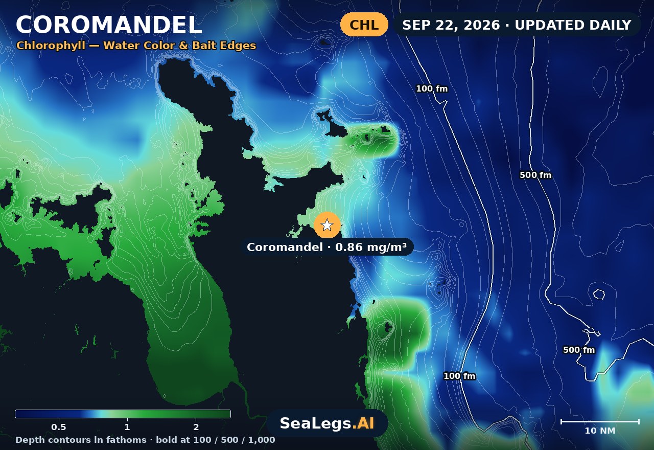
Sea surface temperature and chlorophyll around Coromandel, imaged fresh every morning. Water at the star is 59.0°F today, and chlorophyll of 0.37 mg/m³ reads as green shelf water at the spot.
Imagery: Sep 29, 2026 · rebuilt every morning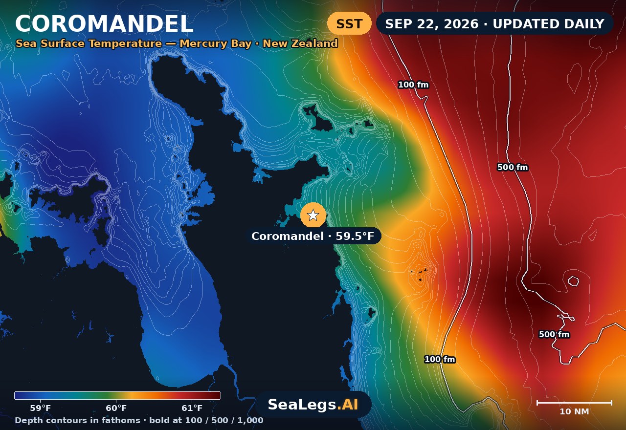
These charts show you the breaks. DeepCast reads them. A zone-by-zone AI fishing report for these exact waters — temperature edges, color changes, and structure, analyzed together.
Get the AI fishing reportSST and chlorophyll from the SeaLegs AI DeepCast satellite pipeline. Charts are a planning aid — always check the official marine forecast before making the run.
About the Coromandel
The eastern Coromandel is snapper country and one of the busiest trailer-boat coasts in New Zealand. Behind the Mercury Islands the water off Whitianga is often sheltered and glassy, which is exactly why it fills up with family boats out of Whitianga and Tairua the moment the wind eases. But the shelter is directional — the same day that's flat in close can be lumpy the moment you push out past the islands onto the open east coast.
This page updates every day with a 3-day outlook for Mercury Bay so you can read the window before you hitch the trailer. Each day gets a plain call — GO / CAUTION / NO-GO — the same AI rating used in the SeaLegs AI app.
Reading conditions off the Coromandel
The islands do the heavy lifting. Tuck in behind the Mercury group and a moderate breeze barely registers. The catch is the open east coast: any easterly swell wraps straight onto the exposed grounds and around the headlands off Whitianga and Tairua, so a benign inshore forecast can still mean a sloppy, uncomfortable day out wide. Check swell direction and period, not just height — a long-period easterly does more to the ride than the number suggests.
The other thing to watch is local wind-chop. Mercury Bay is fetch-limited in close, so a fresh afternoon nor'easter or a squally southwest change stacks up a short, sharp chop fast, even with no real swell behind it. The trailer-boat window is usually the calm early morning before the sea breeze fills in — launch early, watch the afternoon build, and let the GO/CAUTION call keep the family trip on the right side of the line.
Coromandel forecast FAQ
How is the sea at Coromandel today?
As of Sep 30, 2026, the SeaLegs AI verdict for Coromandel is GO. A great day for boating with very light 3-7 knots W/WSW winds all day and small, well-organized 0.6-0.9 feet seas at 8-11 second periods out of the E/ESE - comfortable, long-period swell for most of the day. There's a 61% chance of showers around 4:00 PM, so bring rain gear if you're out in the afternoon, but wind and sea state remain mild and safe throughout. Overnight and morning hours (12:00 AM-11:00 AM) are especially calm and are the pick of the day.
When is the best time of day to launch off Whitianga?
Early. The most settled window on the eastern Coromandel is usually the first few hours after dawn, before the afternoon sea breeze fills in and stacks up chop across Mercury Bay. Get out, fish the morning bite, and be watching the forecast for the afternoon build — that's why the daily GO / CAUTION / NO-GO call is set for the window you'll actually be on the water.
How accurate is this Coromandel marine forecast?
The outlook is generated from the latest marine model data and rated GO, CAUTION, or NO-GO by the same AI engine used in the SeaLegs AI app. It's a planning aid, not a substitute for the official MetService marine forecast and any current warnings — always check those before heading out.
How often is this forecast updated?
The page is rebuilt every morning from the latest model run, and the SpotCast card refreshes live in your browser. The date stamp above the outlook shows exactly when it was last generated.
What do GO, CAUTION, and NO-GO mean?
GO means conditions are favourable for most recreational boats. CAUTION means marginal — manageable for experienced crews in capable vessels, but check the wind and sea timing closely. NO-GO means conditions are hazardous for small craft and the trip is best postponed.
Can I get a forecast like this for my own spot?
Yes. In the free SeaLegs AI app you can drop a pin anywhere on Earth — your local ramp, a favourite mark, or a spot well offshore — and get the same AI-rated marine forecast and trip planning.
What is the water temperature at Coromandel today?
As of Sep 29, 2026, the satellite-derived sea surface temperature at Coromandel is about 59.0°F, with chlorophyll around 0.37 mg/m³ (green shelf water). The SST and chlorophyll charts on this page are rebuilt every morning from the SeaLegs AI DeepCast satellite pipeline.
More offshore forecasts
Get this forecast for your own spot
Drop a pin on any spot on planet Earth in the free SeaLegs AI app — AI marine forecasts, fishing reports, and trip planning, rated GO / CAUTION / NO-GO.
📍 Get a Marine Forecast Near You →or download directly: