Cook Strait Weather & Marine Forecast
Updated Tue Sep 22, 2026
Three-day stretch of rough seas and cross-swell rules out safe travel
Drop a pin on any spot in the world — free in the SeaLegs AI app.


Marine Forecast for Cook Strait Sep 22–24, 2026
📋 Three-day stretch of rough seas and cross-swell rules out safe travel
NO-GO Tuesday: strong overnight/morning winds to 30 knots gusting 40+ with steep 8.6 feet chop, easing to a short afternoon lull before winds return by evening. A confused cross-sea (WNW swell vs SW wind-wave) adds uncomfortable motion, and no window is long enough for a full 12-hour trip.
NO-GO all day Wednesday: sustained 20-25 knots south winds gusting past 30 knots and seas building to nearly 10 feet at 7-8 second periods. Low model confidence (55%) adds uncertainty, but conditions are dangerous throughout with no viable window.
NO-GO Thursday despite much lighter 8-14 knots NW/N winds - lingering S swell keeps seas at 5.4-8.3 feet, crossing with NNW wind-waves for a confused, uncomfortable sea for several hours. No full 12-hour clean window materializes, so it's still a stay-ashore day.
This is a NO-GO period across all three days, driven by strong winds, steep confused seas, and no settled 12-hour window that's clean start to finish. Tuesday and Thursday have brief lulls but not long enough to safely run the full trip, and Wednesday is dangerous nearly around the clock with low forecast confidence.
Today’s Water at Cook Strait
Sea surface temperature and chlorophyll around Cook Strait, imaged fresh every morning. Water at the star is 56.5°F today, and chlorophyll of 0.49 mg/m³ reads as green shelf water at the spot.
Imagery: Sep 21, 2026 · rebuilt every morning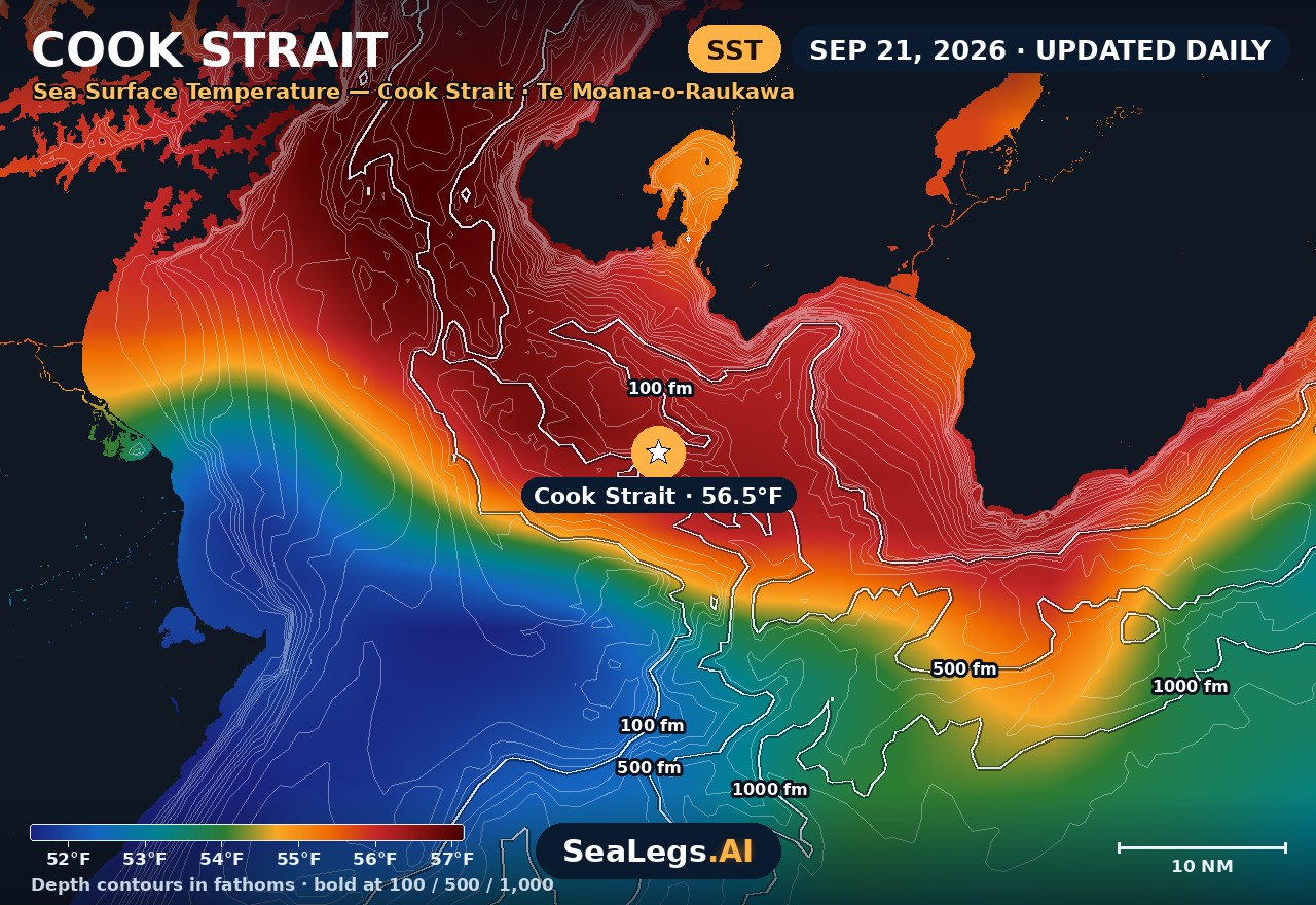
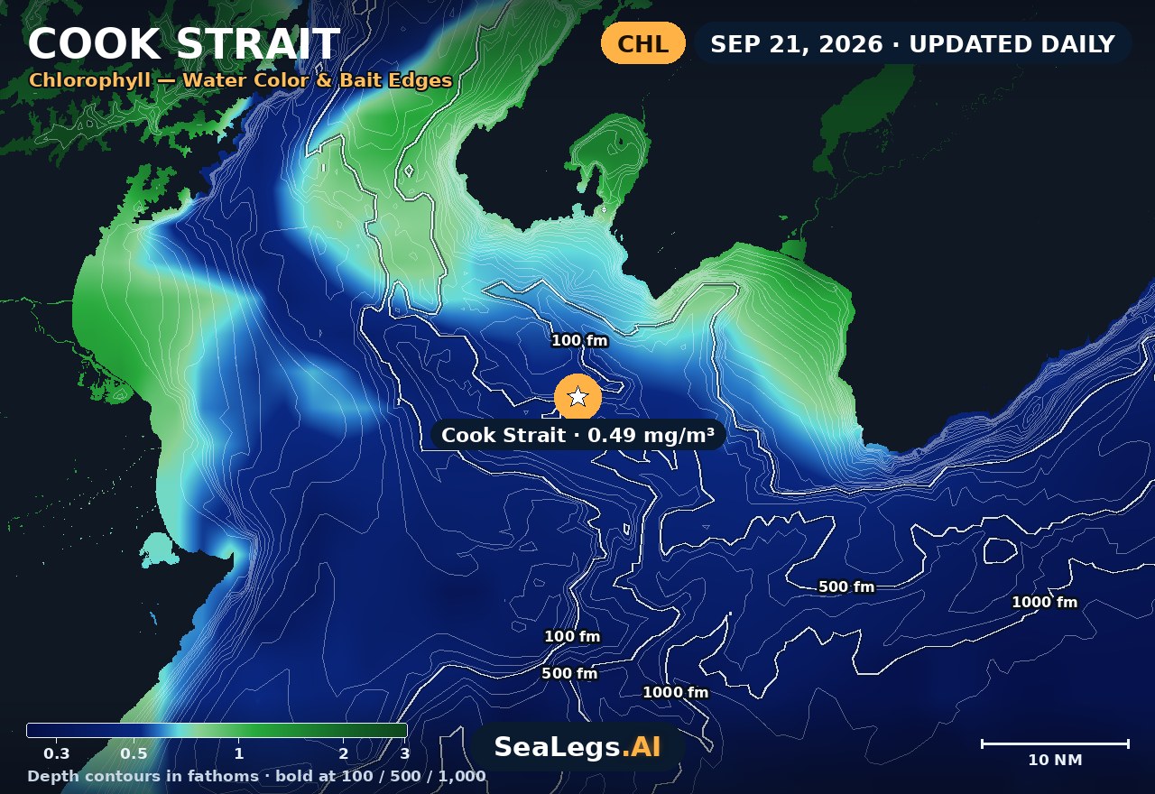
These charts show you the breaks. DeepCast reads them. A zone-by-zone AI fishing report for these exact waters — temperature edges, color changes, and structure, analyzed together.
Get the AI fishing reportSST and chlorophyll from the SeaLegs AI DeepCast satellite pipeline. Charts are a planning aid — always check the official marine forecast before making the run.
About Cook Strait
Cook Strait is the water between New Zealand's North and South Islands, and it has a reputation for rough crossings that it comfortably earns. This forecast covers the open water of the strait — wind, swell and wave height where it is exposed, not inside the shelter of Wellington Harbour or the Marlborough Sounds.
It updates every morning from the latest marine model data, and each day gets an honest GO, CAUTION, or NO-GO call — the same AI rating used in the SeaLegs AI app. Heading out of Wellington rather than across? The Wellington marine forecast is written for that trip.
Why the strait gets rough
At its narrowest the strait is only about 22 km wide, and that gap does something specific to weather: it funnels and accelerates it. The prevailing northwesterlies and southerlies are channelled straight through, so wind in the strait is routinely stronger than the same system either side of it. A regional forecast that looks unremarkable can still mean a hard crossing.
The tide makes it worse. The tides at either end of the strait run largely out of step, so strong streams push through the gap — fastest around the Narrows and off Cape Terawhiti, where the Karori Rip has a name for good reason. Wind against tide is what turns a moderate sea into a short, steep one, so read wind direction against the tide rather than wind speed alone. A southerly adds long-period Southern Ocean swell with nothing in the way.
For a small-boat crossing between Wellington and the Sounds, plan the return leg as carefully as the way over: the strait can change inside a few hours, and it is not a place to be caught deciding late.
On the water around Cook Strait
 Waikawa Boating ClubCook Strait weather linksThe Picton club's own curated list of Cook Strait weather sources.waikawaboatingclub.co.nz
 InterislanderCook Strait ferryThe Wellington–Picton ferry — timetables, sailing conditions and service alerts.interislander.co.nz
 BluebridgeService alertsSailing disruptions and notices for the Bluebridge Cook Strait ferry.bluebridge.co.nz
Marlborough HarbourmasterHarbour noticesCurrent notices and navigation warnings for the Marlborough Sounds side of the strait.marlborough.govt.nz
BluebridgeService alertsSailing disruptions and notices for the Bluebridge Cook Strait ferry.bluebridge.co.nz
Marlborough HarbourmasterHarbour noticesCurrent notices and navigation warnings for the Marlborough Sounds side of the strait.marlborough.govt.nz
Cook Strait forecast FAQ
How is the sea at Cook Strait today?
As of Sep 22, 2026, the SeaLegs AI verdict for Cook Strait is NO-GO. Tuesday is a NO-GO with no settled 12-hour stretch of safe conditions. The day opens dangerously with 28-30 knots NNW/NW winds gusting to 40-41 knots and steep 6-second wind-wave chop building to 8.6 feet overnight into early morning. Winds ease through midday into a brief afternoon lull (1:00 PM-6:00 PM) with sub-10 knot breezes and seas dropping to 5-6 feet at 7-second periods from the south, but this window is too short for the trip and is followed by winds picking back up to 17-21 knots from the NNW by evening. There's also a confused cross-sea for several hours as WNW swell crosses SW-driven wind-waves, producing awkward, uncomfortable motion with no comfortable heading; model agreement on wind speed is only moderate (78% overall confidence), adding uncertainty to timing.
How rough is Cook Strait today?
The GO / CAUTION / NO-GO card at the top of this page is today's answer for the open strait, with the wind, gusts and wave height behind it. It is rebuilt every morning, and the live card refreshes in your browser. Conditions at the Narrows and off Cape Terawhiti can be rougher than the forecast point when the tide is running against the wind.
How rough is the Cook Strait crossing?
It depends almost entirely on wind strength and direction. In light winds the crossing can be calm; in a strong northwesterly or southerly the funnelling effect of the strait builds a steep, uncomfortable sea quickly, and a southerly brings long swell from the Southern Ocean on top. Check the daily wave height and wind here before you commit, and for a ferry sailing, check your operator's own sailing updates — whether a ferry runs is their call.
Does this forecast cover Wellington Harbour or the Marlborough Sounds?
No — deliberately. It is aimed at the exposed water of the strait, because that is what decides a crossing. The harbour and the Sounds are far more sheltered, and a forecast placed inside them would not tell you about the water in between.
How often is this forecast updated?
The page is rebuilt every morning from the latest model run, and the SpotCast card refreshes live in your browser. The date stamp above the outlook shows when it was last generated.
What do GO, CAUTION, and NO-GO mean?
GO means conditions are favourable for most recreational boats. CAUTION means marginal — manageable for experienced crews in capable vessels, but check the wind, tide and sea timing closely. NO-GO means conditions are hazardous for small craft and the trip is best postponed.
What is the water temperature at Cook Strait today?
As of Sep 21, 2026, the satellite-derived sea surface temperature at Cook Strait is about 56.5°F, with chlorophyll around 0.49 mg/m³ (green shelf water). The SST and chlorophyll charts on this page are rebuilt every morning from the SeaLegs AI DeepCast satellite pipeline.
More offshore forecasts
Get this forecast for your own spot
Drop a pin on any spot on planet Earth in the free SeaLegs AI app — AI marine forecasts, fishing reports, and trip planning, rated GO / CAUTION / NO-GO.
📍 Get a Marine Forecast Near You →or download directly: