Bay of Islands Marine Forecast
Updated Mon Sep 28, 2026
Drop a pin on any spot in the world — free in the SeaLegs AI app.


Marine Forecast for Bay of Islands Mon Sep 28, 2026
📋
Today’s Water at Bay of Islands
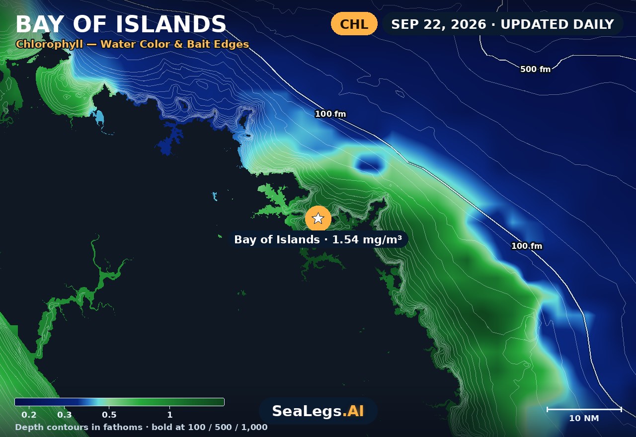
Sea surface temperature and chlorophyll around Bay of Islands, imaged fresh every morning. Water at the star is 59.5°F today, and chlorophyll of 0.6 mg/m³ reads as green shelf water at the spot.
Imagery: Sep 29, 2026 · rebuilt every morning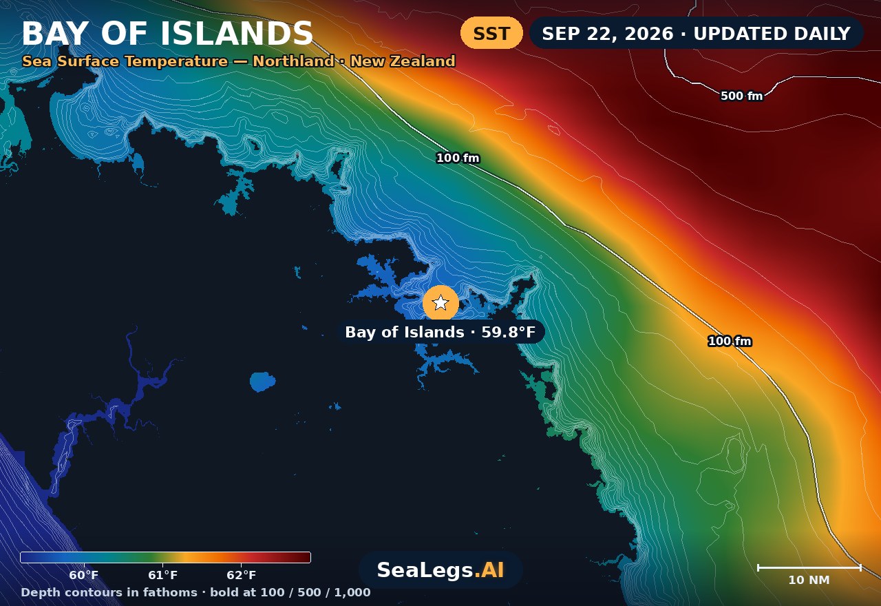
These charts show you the breaks. DeepCast reads them. A zone-by-zone AI fishing report for these exact waters — temperature edges, color changes, and structure, analyzed together.
Get the AI fishing reportSST and chlorophyll from the SeaLegs AI DeepCast satellite pipeline. Charts are a planning aid — always check the official marine forecast before making the run.
About the Bay of Islands
The Bay of Islands hides its weather. Launch from Paihia, Ōpua, or Russell and the inner waters between the ~144 islands can sit glassy while a solid easterly swell is already stacking up on the open Pacific — the two conditions rarely match. Whether you're bottom-bouncing for snapper close in or running out to the game grounds for a summer marlin, the call comes down to how much exposure you'll take once you clear the last island.
This page updates daily with a live 3-day outlook so you can see the trend before you commit to a launch. Each day carries a plain GO / CAUTION / NO-GO rating — the same AI rating used in the SeaLegs AI app.
Reading conditions in the Bay of Islands
The Bay's defining feature is shelter. Tucked inside the islands, you're screened from most swell and a good chunk of the wind, which is why snapper and kingfish sessions close to Russell or the inner channels can run on days that look marginal on paper. The moment you push past the outer islands toward the game grounds, that protection ends — you're on the open Pacific, exposed to easterly and northeasterly swell with nothing to knock it down.
Easterly swell is the one to watch. A modest inner-bay reading can mask a long-period easterly groundswell that only shows its teeth on the outer grounds, where wind-against-tide over the deeper edges stands the sea up fast. Read the swell period, not just the height: short-period wind chop eases as the breeze backs off, but long-period groundswell holds regardless. Summer game trips (marlin Jan–Apr) reward an early start and a settled easterly quarter; if the forecast has the swell building through the day, run early and be back inside the islands before it peaks.
Bay of Islands forecast FAQ
Is the Bay of Islands protected enough to fish when it's rough offshore?
Often, yes. The inner waters between the islands are well sheltered, so snapper and kingfish grounds near Paihia, Ōpua, and Russell can stay fishable when the open coast is blown out. The catch is the game grounds beyond the outer islands — those are fully exposed to easterly swell and the open Pacific, so a calm inner bay tells you little about conditions once you clear the last island. Check the outer-water rating separately before committing to an offshore run.
How accurate is this Bay of Islands marine forecast?
The outlook is generated from the latest marine model data and rated GO, CAUTION, or NO-GO by the same AI engine used in the SeaLegs AI app. It's a planning aid, not a substitute for the official MetService marine forecast and any current warnings — always check those before heading out.
How often is this forecast updated?
The page is rebuilt every morning from the latest model run, and the SpotCast card refreshes live in your browser. The date stamp above the outlook shows exactly when it was last generated.
What do GO, CAUTION, and NO-GO mean?
GO means conditions are favourable for most recreational boats. CAUTION means marginal — manageable for experienced crews in capable vessels, but check the wind and sea timing closely. NO-GO means conditions are hazardous for small craft and the trip is best postponed.
Can I get a forecast like this for my own spot?
Yes. In the free SeaLegs AI app you can drop a pin anywhere on Earth — your local ramp, a favourite mark, or a spot well offshore — and get the same AI-rated marine forecast and trip planning.
What is the water temperature at Bay of Islands today?
As of Sep 29, 2026, the satellite-derived sea surface temperature at Bay of Islands is about 59.5°F, with chlorophyll around 0.6 mg/m³ (green shelf water). The SST and chlorophyll charts on this page are rebuilt every morning from the SeaLegs AI DeepCast satellite pipeline.
More offshore forecasts
Get this forecast for your own spot
Drop a pin on any spot on planet Earth in the free SeaLegs AI app — AI marine forecasts, fishing reports, and trip planning, rated GO / CAUTION / NO-GO.
📍 Get a Marine Forecast Near You →or download directly: