Vancouver Marine ForecastStrait of Georgia
Updated Sat Sep 12, 2026
Windy Saturday chop eases into calm Sunday and Monday
Drop a pin on any spot in the world — free in the SeaLegs AI app.


Marine Forecast for Strait of Georgia Sep 12–14, 2026
📋 Windy Saturday chop eases into calm Sunday and Monday
Saturday starts calm but WNW winds build to 16-18 knots with gusts near 24 knots by afternoon, kicking up steep 2-second-period chop to 2.4 feet. Best to boat before 9:00 AM or wait until after 9:00 PM when winds relax. Afternoon conditions call for caution on the water.
Sunday offers good conditions with light 10-16 knots E/ESE winds and 1-1.8 foot seas at short 2-second periods. Midday from 12:00 PM to 4:00 PM is nearly calm with winds dropping to single digits. A modest evening wind increase to 16 knots with gusts to 22 knots is worth noting but not a major concern.
Monday brings the best conditions of the period: light 7-14 knots ESE winds easing to near-calm by afternoon, with tiny 0.5-1.5 foot seas. Visibility is excellent and conditions stay favorable all day, especially from late morning onward. Ideal day to be on the water.
Saturday brings building WNW winds and short-period chop that push conditions into caution territory by afternoon, while Sunday and Monday settle into light winds and small, well-organized seas ideal for boating. Model confidence is high (95%) across all three days, so the forecast trend can be trusted.
Recent days at Strait of Georgia
Today’s Water at Strait of Georgia
Sea surface temperature and chlorophyll around Strait of Georgia, imaged fresh every morning. Water at the star is 61.4°F today, and chlorophyll of 7.15 mg/m³ reads as nutrient-rich green water at the spot.
Imagery: Sep 11, 2026 · rebuilt every morning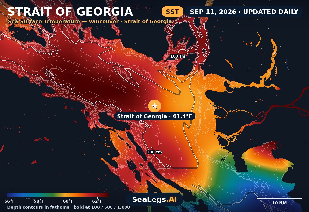
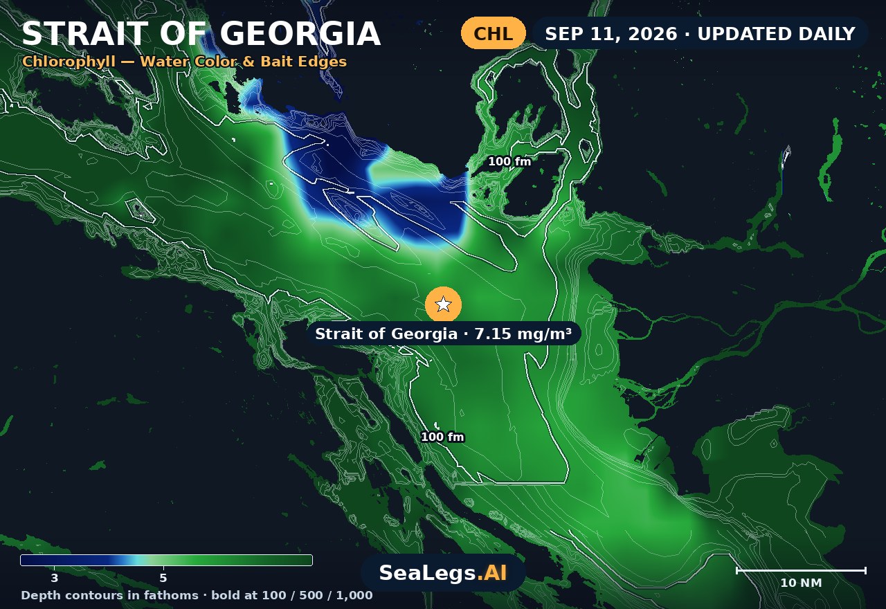
These charts show you the breaks. DeepCast reads them. A zone-by-zone AI fishing report for these exact waters — temperature edges, color changes, and structure, analyzed together — for $4.99.
Get the AI fishing reportSST and chlorophyll from the SeaLegs AI DeepCast satellite pipeline. Charts are a planning aid — always check the official marine forecast before making the run.
About the Strait of Georgia
This forecast covers the open Strait of Georgia — the water between Vancouver and Nanaimo, roughly 30 km from either shore. That placement is deliberate: it is the crossing itself, not the shelter of Burrard Inlet or Departure Bay, that decides whether a day on the water works.
It updates every morning from the latest marine model data, and each day gets an honest GO, CAUTION, or NO-GO call — the same AI rating used in the SeaLegs AI app.
Reading the Strait of Georgia
The strait is sheltered from Pacific swell by Vancouver Island, so the sea you meet here is almost entirely locally generated wind chop rather than long-period swell arriving from offshore. That changes how you read a forecast: wave height alone understates it. A 20-knot northwesterly blowing the length of the strait builds a short, steep, closely-spaced sea that is far more punishing than the same wave height would be offshore.
Two local patterns matter. Summer afternoons commonly bring a northwesterly that fills in and builds through the day, so a calm morning crossing is not a promise about the return leg — plan both. And through the cooler months, outflow winds funnelling down the inlets from the interior can arrive strong and cold with little warning. Tidal streams run hard around the Gulf Islands passes, and wind against tide there stands the sea up fast.
This page is a planning aid, not a substitute for Environment Canada's marine forecasts and warnings — always check those before you leave the dock.
Strait of Georgia forecast FAQ
How is the sea at Strait of Georgia today?
As of Sep 12, 2026, the SeaLegs AI verdict for Strait of Georgia is CAUTION. Saturday is a caution day as WNW winds steadily build through the day, starting around 10-12 knots in the early morning but climbing to 16-18 knots with gusts up to 23-24 knots by mid-afternoon and evening. Wave heights grow from about 1 foot to 2.4 feet, but with only 2-second periods from the NW, the sea state stays short and choppy rather than smooth, making for a bouncy ride especially from noon onward. Best to get on the water early (before 9:00 AM) or wait until after 9:00 PM when winds finally ease back to single digits, though a wind shift from NW to E overnight could bring a brief bumpy transition.
Does this forecast cover Nanaimo as well as Vancouver?
Yes. The forecast point sits mid-strait, roughly 32 km from Vancouver and 29 km from Nanaimo, so it describes the open water of the crossing that both cities share rather than either harbour. If you're leaving from Departure Bay or Burrard Inlet, expect conditions inshore to be milder than what's shown here.
Why is the Strait of Georgia rougher than the wave height suggests?
Because the strait is sheltered from Pacific swell by Vancouver Island, nearly all of its sea is locally generated wind chop. Wind waves are short and closely spaced, so a 1.5 m sea in the strait is a considerably harder ride than 1.5 m of long-period ocean swell. Read the wind and the wave period together, not the height on its own.
When is the wind strongest in the Strait of Georgia?
In summer the common pattern is a northwesterly that fills in and strengthens through the afternoon, which is why mornings are often the calmer half of the day. In the cooler months, outflow winds funnelling down the coastal inlets from the interior can arrive strong with little warning.
How often is this forecast updated?
The page is rebuilt every morning from the latest model run, and the SpotCast card refreshes live in your browser. The date stamp above the outlook shows when it was last generated.
What do GO, CAUTION, and NO-GO mean?
GO means conditions are favourable for most recreational boats. CAUTION means marginal — manageable for experienced crews in capable vessels, but check the wind and sea timing closely. NO-GO means conditions are hazardous for small craft and the trip is best postponed.
What is the water temperature at Strait of Georgia today?
As of Sep 11, 2026, the satellite-derived sea surface temperature at Strait of Georgia is about 61.4°F, with chlorophyll around 7.15 mg/m³ (nutrient-rich green water). The SST and chlorophyll charts on this page are rebuilt every morning from the SeaLegs AI DeepCast satellite pipeline.
More offshore forecasts
Get this forecast for your own spot
Drop a pin on any spot on planet Earth in the free SeaLegs AI app — AI marine forecasts, fishing reports, and trip planning, rated GO / CAUTION / NO-GO.
📍 Get a Marine Forecast Near You →or download directly: