Cabo San Lucas Marine ForecastLand's End, Baja California Sur
Updated Sun Oct 11, 2026
NO-GO: steep S swell and crossing seas all 3 days
Drop a pin on any spot in the world — free in the SeaLegs AI app.


Marine Forecast for Cabo San Lucas Oct 11–13, 2026
📋 NO-GO: steep S swell and crossing seas all 3 days
NO-GO. Winds are light, but a 6.2-6.6 foot S swell at 11 seconds crosses the W wind-wave, creating a confused cross-sea with awkward motion and no good heading. No window is long enough for a 12-hour trip.
NO-GO for a 12-hour trip. Calm winds, but an SSW swell crosses the W wind-wave, creating a confused cross-sea for about 8 hours. Seas build and rate bad after 5:00 PM.
NO-GO. Light winds, but a 5.6-6.2 foot S swell at 12 seconds and an SSW swell crossing WNW wind-wave cross-sea for about 4 hours make for awkward motion. No window fits a 12-hour trip.
Winds are very light (under 6 knots) all three days, but a persistent 5.5-6.6 foot south to south-southwest swell at 11-13 second periods keeps sea state the limiting factor. None of the three days has a settled stretch long enough for a 12-hour trip, so the overall call is NO-GO. Model confidence is moderate to good (73-82%), with wind speed the least certain parameter.
Recent days at Cabo San Lucas
Today’s Water at Cabo San Lucas
Sea surface temperature and chlorophyll around Cabo San Lucas, imaged fresh every morning. Water at the star is 87.8°F today, and chlorophyll of 0.15 mg/m³ reads as blue-green transition water at the spot.
Imagery: Oct 11, 2026 · rebuilt every morning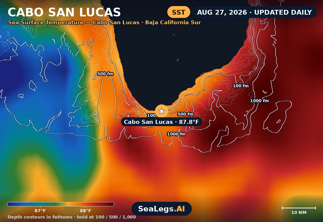
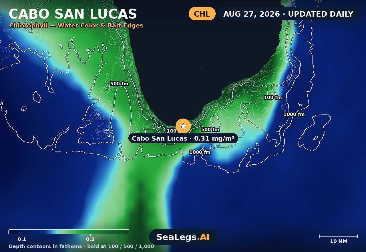
These charts show you the breaks. DeepCast reads them. A zone-by-zone AI fishing report for these exact waters — temperature edges, color changes, and structure, analyzed together.
Get the AI fishing reportSST and chlorophyll from the SeaLegs AI DeepCast satellite pipeline. Charts are a planning aid — always check the official marine forecast before making the run.
About Cabo San Lucas
Cabo San Lucas sits at the very tip of Baja California Sur, where the Pacific meets the Sea of Cortez at Land's End — and that meeting point is exactly why one number for "Cabo" misleads. A morning that is glassy inside the bay can be a stiff, lumpy ride the moment you round the point and turn up the Pacific side.
This page reads the water at the harbour mouth itself, where every trip starts and finishes. Each day gets an honest GO, CAUTION, or NO-GO call, rebuilt every morning from the latest marine model data — the same AI rating used in the free SeaLegs AI app.
Reading the water at Land's End
Two different oceans meet at the cape, and they rarely behave the same way on the same day. The Pacific side takes the open swell and is where the offshore banks sit — Golden Gate about 17 nautical miles west-northwest and San Jaime about 20 nautical miles west-southwest, both seamounts whose upwelling stacks bait. The Sea of Cortez side, up toward the Gordo Banks, is generally the more sheltered option when the Pacific stands up — which makes the decision at Land's End less "can I go" than "which way do I turn".
Season matters as much as the daily number. Late summer into autumn is the tail of the eastern Pacific hurricane and tropical-storm season, and a system still far offshore can lay a long southerly groundswell on the cape under a clear sky and a light breeze — which is why swell period deserves as much weight as height here. A long-period swell rides very differently from short wind chop at the same reading. In winter the pattern flips: northerlies funnel down the Sea of Cortez and it is the Cortez side that turns uncomfortable. Plan the whole day rather than just the departure, and always confirm the official marine forecast and warnings before you leave the dock — this page is a planning aid, not a substitute for them.
Cabo San Lucas forecast FAQ
How is the sea at Cabo San Lucas today?
As of Oct 11, 2026, the SeaLegs AI verdict for Cabo San Lucas is NO-GO. NO-GO all day Sunday. Winds are very light (2 to 5 knots from the northwest, shifting through the south and west by afternoon) but waves are the problem: a 6.2 to 6.6 foot swell from the south at 11-second periods is crossing the wind-wave, which turns from the west. This SE swell crossing W wind-wave setup creates a confused cross-sea, with two wave trains arriving from different directions, awkward uncomfortable motion, and no single good heading. Waves rate bad until about 10:00 PM and only ease to caution late evening, with no settled stretch long enough for a 12-hour trip. Model agreement on wind speed is low, so wind shifts could differ from the forecast.
What is the marine forecast for Cabo San Lucas today?
The board above shows today's conditions at the harbour mouth at Land's End — wind, swell, and a plain GO, CAUTION, or NO-GO rating — rebuilt every morning from the latest marine model data. Because the Pacific and the Sea of Cortez meet at the cape, treat it as the departure read rather than a single number for every direction you might run.
Why can conditions differ so much on either side of Cabo?
Land's End is the dividing point between open Pacific water and the Sea of Cortez. The Pacific side takes the ocean swell and is where the offshore banks sit; the Cortez side is often calmer in summer and autumn but is the rougher one in winter, when northerlies funnel down the gulf. It is common for one side to be fishable and the other not on the same morning.
How far are the offshore banks from Cabo San Lucas?
Golden Gate Bank lies about 17 nautical miles west-northwest of Land's End and San Jaime Bank about 20 nautical miles west-southwest — both open-Pacific runs with no shelter along the way. The Gordo Banks sit the other way, up the Sea of Cortez side.
When is the best fishing season at Cabo San Lucas?
It depends on the fish. Blue and black marlin peak from roughly July through October, which is why the big-money tournaments run in October — the overlap weeks when marlin, yellowfin tuna, dorado and wahoo are all in the water together. Striped marlin are the area's most abundant billfish but peak in the cooler months, roughly December through June.
How often is this Cabo San Lucas forecast updated?
The forecast on this page is rebuilt every morning from the latest marine model data, and the SpotCast card refreshes live in your browser. The date stamp above the outlook shows exactly when it was last generated.
What do GO, CAUTION, and NO-GO mean?
GO means conditions are favorable for most recreational boats. CAUTION means marginal — manageable for experienced crews in capable vessels, but check the wind, swell period, and timing closely. NO-GO means conditions are hazardous for small craft and the trip is best postponed.
Can I get a forecast like this for my own spot off Cabo?
Yes. In the free SeaLegs AI app you can drop a pin on any spot on Earth — the Golden Gate, San Jaime, the Gordo Banks, or your own numbers — and get the same AI-rated marine forecast, plus DeepCast AI fishing reports and trip planning.
What is the water temperature at Cabo San Lucas today?
As of Oct 11, 2026, the satellite-derived sea surface temperature at Cabo San Lucas is about 87.8°F, with chlorophyll around 0.15 mg/m³ (blue-green transition water). The SST and chlorophyll charts on this page are rebuilt every morning from the SeaLegs AI DeepCast satellite pipeline.
More offshore forecasts
Get this forecast for your own spot
Drop a pin on any spot on planet Earth in the free SeaLegs AI app — AI marine forecasts, fishing reports, and trip planning, rated GO / CAUTION / NO-GO.
📍 Get a Marine Forecast Near You →or download directly: