Open your phone's default weather app and you'll get a high of 78, light winds, partly cloudy. Perfect for deciding what to wear. Useless for deciding whether to run twenty miles offshore for tuna — or which grass flat will turn on at the bottom of the tide.
Catching fish isn't a weather problem. It's an ocean problem. The conditions that decide whether the bite is on — water temperature edges, water color, current, the moon — never appear in a normal weather app. A real fishing weather app surfaces them, and the best ones do the interpreting for you.
We compared seven of the most-used fishing apps for the 2026 season. First, the six signals that actually separate a fishing app from a weather app — then the lineup, and which one to pick for how you fish.
The 6 Signals That Actually Find Fish
1. Sea-surface temperature (SST) and temperature breaks. Fish hold on thermal edges. Offshore, a two-degree temperature break can be the difference between empty blue water and a tuna highway — pelagics like tuna, marlin, and mahi stack along the warm side of a break where bait collects. Inshore, species have temperature windows that switch the bite on and off seasonally. An app that shows you SST and, better, the breaks between water masses is showing you structure you can't see from the surface.
2. Chlorophyll and water color. This is the offshore angler's edge most apps ignore. Chlorophyll concentration is a proxy for plankton — and plankton is the base of the food chain. Where clean blue water meets greener, plankton-rich water, you get a color change line that concentrates bait, and predators behind it. Pair chlorophyll with SST and you're reading the same map the best offshore captains run: find the temp break and the color edge, and you've found the fish. Very few consumer apps put chlorophyll in front of you. The ones that do are a different class of tool.
3. Altimetry (sea-surface height). Satellites measure the ocean's surface height to the centimeter, and those tiny rises and dips reveal what's moving underneath — eddies, current edges, and the convergence zones where warm and cold water masses meet. Offshore, a spinning eddy or a current break stacks bait and pelagics the same way a temperature break does, and altimetry is how you spot one before you ever leave the dock. It's the third satellite layer — alongside SST and chlorophyll — that the sharpest offshore tools put together. (More on fishing these features in our ocean eddy fishing guide.)
4. Solunar / bite windows. The sun and moon drive feeding activity. Solunar tables predict major and minor feeding periods for any day and location, and lining your trip up with a major period stacked on sunrise or a tide change is one of the oldest edges in fishing. An app that overlays solunar on the rest of the forecast saves you cross-referencing three sources.
5. Tides and tidal current. Inshore, current is the bite. The speed and direction of moving water decides whether fish feed on a flat, in an inlet, or along a bridge. Generic weather apps don't carry tide and current; fishing apps do — and the good ones show you the current at your spot, not just the tide table for the nearest gauge.
6. Barometric pressure trend. The most overlooked variable in casual fishing. It's not the pressure number that matters — it's the trend. Falling pressure ahead of a front often triggers a feeding window; flat high pressure can shut a bite down. An app that shows pressure trend, not just today's reading, is built for anglers.
Wind, wave height, and wave period still matter — but mostly for getting out and back safely. (For how wave period changes the ride, see Understanding Wave Height and Period.) The six signals above are what decide whether you catch.
The 7 Best Fishing Weather Apps for 2026
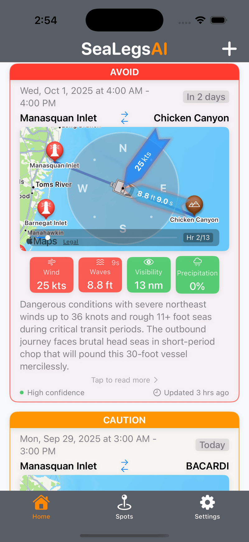
1. SeaLegs AI — Best for the "Where and When" Answer
SeaLegs AI is built around a simple idea: don't make the angler do the oceanography. It fuses sea-surface temperature, chlorophyll, and the marine forecast, then turns it into a plain-language AI fishing report for your spot — where the temperature breaks and color edges are setting up, when the solunar and tide windows line up, and whether it's even worth the run. Its DeepCast fishing reports read the SST and chlorophyll maps for you and name the conditions in words, not raw layers.
What it gets right: it connects the dots. Instead of opening one app for SST, another for chlorophyll, a solunar table, and a tide chart, you get one read that already combined them. The forecast works for any spot on the water, and the free tier is real — no credit card to start.
What it isn't: a raw GRIB-file viewer for people who'd rather interpret the models themselves. If that's you, see Windy below.
Best for: anglers who want the conditions interpreted into a clear plan, not a pile of layers to decode.
Stop guessing. Get the where & when.
SeaLegs AI reads the sea-surface temperature, chlorophyll, and solunar for your spot and turns it into a plain-language fishing report — so you know where the fish should be and when to go. Free to try.
Get your fishing report free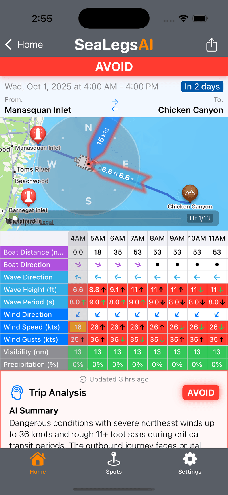
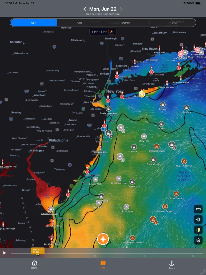
2. Windy — Best Free Visualization
Windy is the visualization standard, and it's genuinely strong for fishing because it carries the right layers: wind, swell, currents, and sea-surface temperature, across multiple weather models, on a beautiful free map. If you like to study your spot yourself and read the SST and current edges with your own eyes, nothing free does it better. (One gap worth knowing: Windy doesn't have a chlorophyll layer — for water-color data you'll need one of the offshore charting services below.)
The trade-off is the same as always: Windy gives you the data, not the answer. You'll see the temperature gradient and the current edges — and you'll have to decide what they mean for the bite. For experienced offshore anglers, that's a feature. For everyone else, it's homework.
Best for: anglers who like to read the layers themselves and want the best free map to do it on.
3. Offshore SST & Chlorophyll Charts (FishTrack, SiriusXM Fish Mapping, Rip Charts)
This is a category, not one app — the satellite-charting services serious offshore crews have run for years. They specialize in high-resolution SST and chlorophyll imagery, plus altimetry, bathymetry, and ocean-current overlays — temperature-break and color-edge detection built specifically for finding pelagics offshore. SiriusXM Fish Mapping even feeds species-specific recommendation zones straight to a Garmin chartplotter up to 150 miles out. If your fishing is canyon-and-bluewater tuna and billfish, this is the imagery standard.
The trade-offs: they're subscription tools focused on imagery rather than a complete go/no-go forecast, and the offshore-satellite depth is overkill for inshore and nearshore anglers.
Best for: dedicated offshore anglers who want the deepest SST/chlorophyll satellite imagery and will interpret it themselves.
4. Fishbrain — Best for New Water and Community Intel
Fishbrain is a fishing social network first and a forecast app second, but the combination works. It overlays conditions and solunar predictions — its BiteTime forecast, trained on millions of logged catches — on a map of recent catches near you, so you can see what conditions produced bites at a spot. With a catalog of 14 million-plus catch locations and Navionics depth charts built in, it's hard-to-replicate context when you're fishing unfamiliar water.
The forecasting itself is competent rather than best-in-class; the catch-data layer is the reason to use it.
Best for: anglers fishing new water who want crowd-sourced spot intelligence next to the forecast.
5. FishWeather — Fishing-Specific Point Forecasts
FishWeather is built for anglers, foregrounding the variables that matter — wind at water level, barometric pressure trend, water temp, tides, moon phase — and pulling from a 125,000+ station network with its Nearcast AI for hyperlocal, spot-level point forecasts. Solid data density, with a steeper learning curve than the consumer apps here.
Best for: experienced anglers who want maximum data density and don't mind a busier interface.
6. PredictWind — Best for Offshore Weather Windows
PredictWind started in sailing, and it shows in its long-range forecasts and weather routing. For offshore anglers planning multi-day trips around weather windows, the departure planning and model comparison are genuinely useful. The features that matter sit behind paid plans.
Best for: offshore anglers running long-range trips who plan around weather windows.
7. NOAA / Your Default Weather App — Fine for the Drive, Not the Trip
NOAA's marine forecasts are the authoritative free baseline, and apps like Apple Weather or AccuWeather are excellent general tools. But none surface SST, chlorophyll, solunar, current, or pressure trend the way fishing demands. On a calm, fair-weather Saturday, the baseline is enough. The moment conditions get marginal — or you want to actually find fish instead of just stay safe — you need a tool built for the question.
Best for: the baseline forecast and non-fishing days. Use a real fishing app to plan the trip.
Which Fishing App Should You Pick?
- You want the conditions interpreted into a clear "where and when" plan → SeaLegs AI
- You like reading SST and current layers yourself, for free → Windy
- You fish blue water offshore and want the deepest satellite imagery → an SST/chlorophyll charting service (FishTrack, SiriusXM Fish Mapping, Rip Charts)
- You're fishing new water and want to see what others caught → Fishbrain
- You want maximum fishing-specific data density → FishWeather
- You plan long-range offshore trips around weather windows → PredictWind
- You just want the authoritative free baseline → NOAA
Plenty of anglers run two — a visualization tool plus one that gives the answer. There's no rule against it.
A Quick Word on Free vs Paid
Most of these have a free tier, but free doesn't always mean complete. If you fish a few times a year in fair weather, free tiers cover you. If you fish weekly — especially offshore, where the SST and chlorophyll edges that find fish live behind paid imagery on most tools — an app that puts those signals together and reads them for you pays for itself the first time it saves you a fishless run.
Most anglers do best with two tools: a free visualization app like Windy to eyeball the SST and current layers, and one that does the interpreting — SeaLegs AI, which reads SST, chlorophyll, and solunar for your spot and hands you a plain-language plan. One shows you the ocean; the other tells you where and when to fish it.