Gulf of Mexico
Eddy Forecasts with Weather Intelligence
Track Loop Current eddies in real time with integrated weather overlays. Know exactly where warm-core rings are concentrating bait and when conditions are safe to make the run offshore.
Buy Now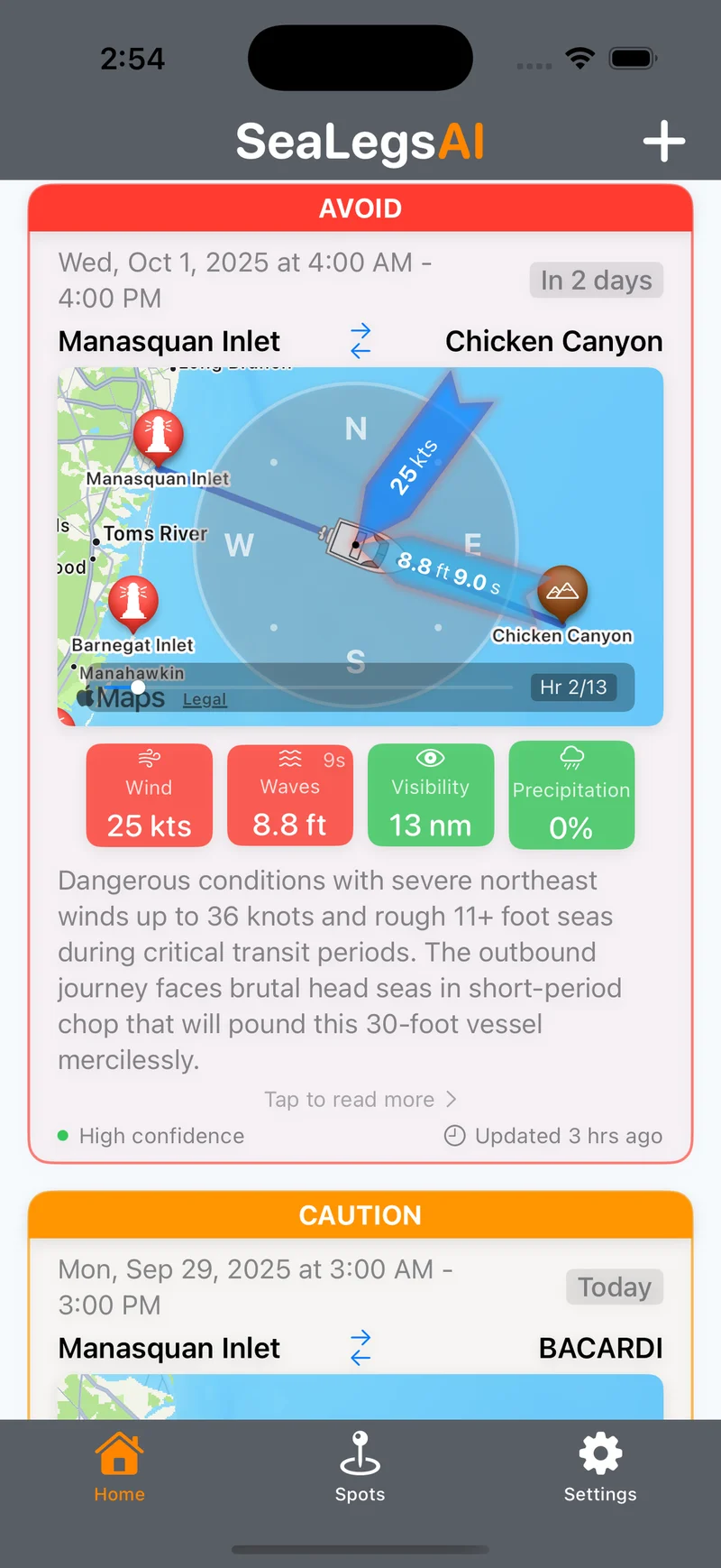
The Gulf's Loop Current: A Fishing Powerhouse
The Gulf of Mexico's Loop Current system is one of the most dynamic eddy-generating ocean currents in the world. As the Loop Current extends northward from the Caribbean, it periodically sheds massive warm-core rings — anticyclonic eddies that can span over 200 miles in diameter. These eddies drift westward across the Gulf, carrying warm, nutrient-rich water that concentrates baitfish, flying fish, and squid along their edges.
For offshore anglers, Loop Current eddies represent some of the most productive fishing grounds in the Gulf of Mexico. The temperature breaks along eddy edges attract bluefin tuna, yellowfin tuna, wahoo, mahi-mahi, and swordfish in impressive numbers. Key departure ports include Venice, Louisiana; Orange Beach, Alabama; Destin, Florida; and Port Aransas, Texas. Peak eddy fishing season runs from April through October, though bluefin tuna can be targeted near the Loop Current as early as January.
EddyCast scores every eddy out of 100 for fishing potential and assigns GO, CAUTION, or AVOID weather ratings so you know which eddies are fishable right now. Each report includes SST maps with thermal gradients, per-eddy details (thermal break, radius, rotation speed, core temperature), target species, "Where to Fish" and "Tactics" guidance, and a "Best Day" recommendation with the safest weather window.
Gulf of Mexico Features
Purpose-built tools for tracking Loop Current eddies and Gulf weather.
Fishing Score per Eddy
Every Loop Current eddy gets a Fishing Score out of 100 based on thermal break strength, rotation speed, and bait potential. The regional overview highlights the "Top Pick" eddy so you know where to focus.
GO / CAUTION / AVOID Ratings
Each eddy gets a color-coded weather safety rating — the same GO, CAUTION, and AVOID system you know from SeaLegsAI. See at a glance which eddies have safe weather windows and which to skip this week.
SST Maps & Eddy Details
Visualize sea surface temperature maps with thermal gradient overlays. Drill into each eddy for coordinates, thermal break (in degrees F), radius (km), rotation speed (kts), and core temperature.
Target Species & Tactics
Each eddy report lists target species (bluefin, yellowfin, wahoo, mahi, swordfish) with "Where to Fish" positioning guidance and recommended tactics. Plus a "Best Day" pick with the optimal weather window.
EddyCast Pricing
Choose the plan that fits your fishing schedule.
- Fishing Score per eddy (/100)
- GO/CAUTION/AVOID weather rating
- SST map with thermal gradients
- Target species & tactics
- Unlimited eddy forecasts
- "Best Day" recommendations
- Per-eddy detail & coordinates
- "Where to Fish" guidance
- Priority support
- Everything in Monthly
- Save 42% vs monthly
- Multi-region access
- Regional "Top Pick" highlights
- Early feature access
Gulf of Mexico EddyCast FAQ
What are Loop Current eddies and why do they matter for fishing?
Loop Current eddies are large warm-core rings that spin off the main Loop Current in the Gulf of Mexico. These eddies concentrate baitfish and plankton along their edges, attracting predators like bluefin tuna, yellowfin tuna, and wahoo. Fishing the edges of these eddies is one of the most productive offshore strategies in the Gulf.
When is the best season for eddy fishing in the Gulf of Mexico?
The prime season for Gulf of Mexico eddy fishing runs from April through October. Bluefin tuna are most active from January through June, while yellowfin and wahoo peak during the warmer months. Loop Current eddies can form year-round, but the most productive fishing conditions occur during the spring and summer months.
How does EddyCast handle tropical weather in the Gulf?
EddyCast integrates real-time weather data with eddy tracking, so you always see current and forecasted conditions overlaid on eddy positions. During hurricane season (June-November), the weather layer helps you plan safe windows to fish productive eddy edges without getting caught in dangerous weather.
How far offshore are Loop Current eddies in the Gulf of Mexico?
Loop Current eddies typically occur 80-150 miles offshore in the central and western Gulf of Mexico. The Loop Current itself can extend north to the Mississippi River delta region. EddyCast tracks these features in real time so you can plan the most efficient run to productive water.
Explore Other Regions
EddyCast Overview
Learn about EddyCast AI ocean eddy forecasting for offshore fishing.
US East Coast
Gulf Stream warm-core rings for tuna, marlin, and mahi-mahi.
US West Coast
California Current eddies for albacore, yellowfin, and dorado.
Northeast US
Georges Bank warm-core rings for giant bluefin and bigeye tuna.
Southeast US
Gulf Stream eddies for sailfish, mahi-mahi, and tuna.
Hawaii
Island wake eddies for yellowfin, bigeye, and Pacific blue marlin.
Mediterranean
Algerian Current eddies for Atlantic bluefin tuna.
Eastern Australia
East Australian Current eddies for marlin, yellowfin, and southern bluefin.
South Africa
Agulhas Current eddies for yellowfin tuna, marlin, and swordfish.
Get Gulf of Mexico Eddy Forecasts
Be the first to access EddyCast when it launches. AI-powered eddy tracking and weather intelligence for Gulf of Mexico offshore fishing.
Buy Now