Jupiter Offshore Fishing ReportWeek of Sep 14 · out of Jupiter Inlet
Weekly report · published Friday, September 18, 2026
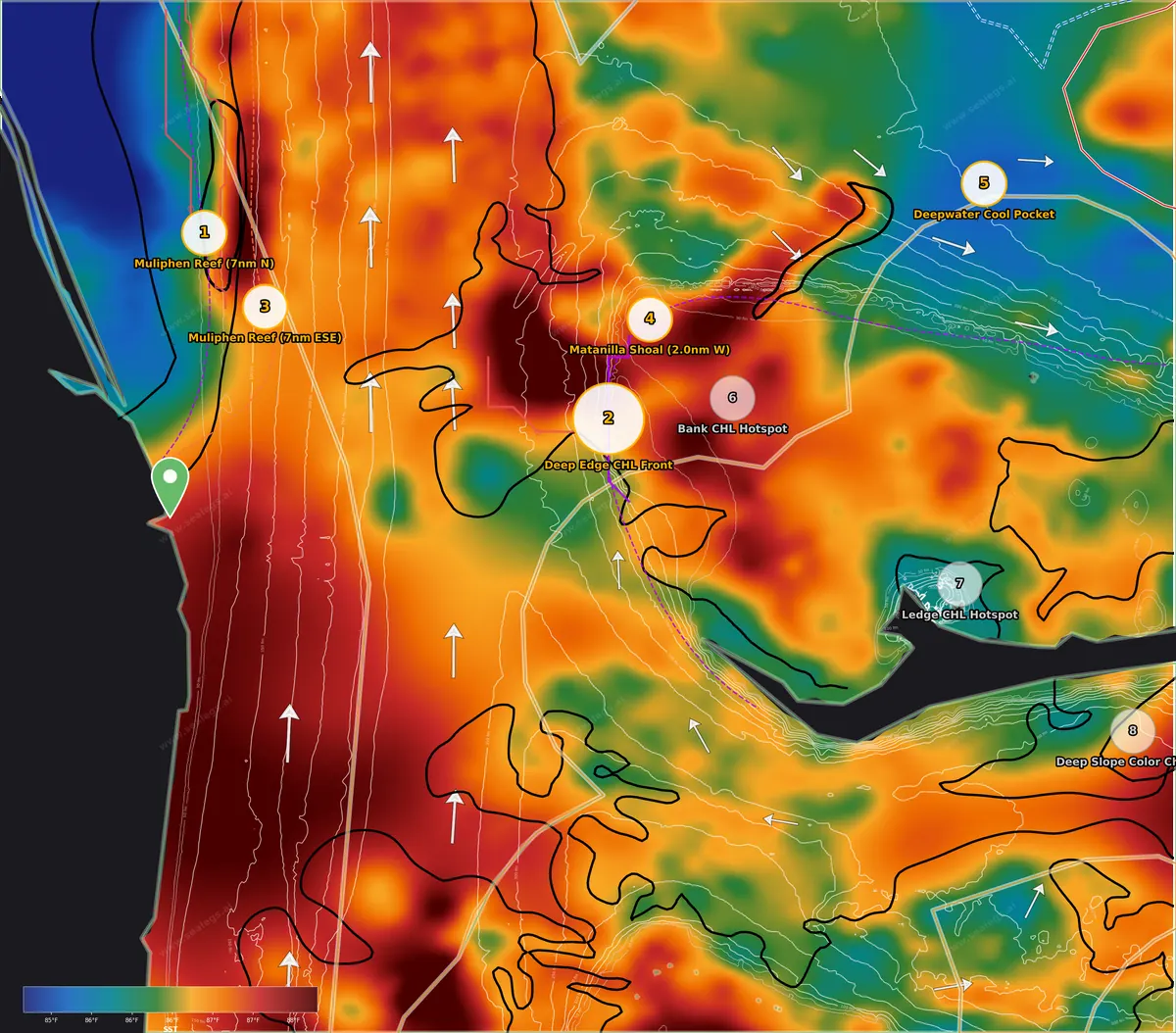
Sea surface temperature. Warm-to-cool breaks are where bait and pelagics stack.
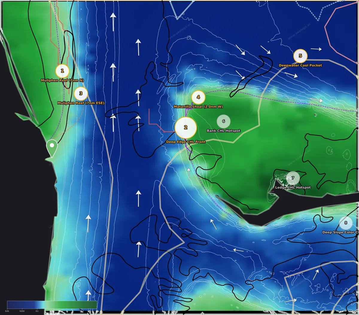
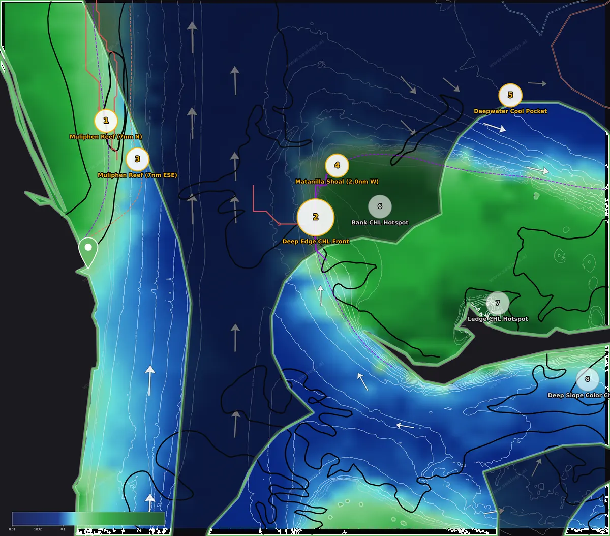
Chlorophyll. Green-to-blue color edges mark where productive water meets clean blue water.
This week's read
The story this week is the western wall of the Gulf Stream sitting right over the Jupiter–Stuart shelf. A 2.5°F temperature break has held its ground north of Muliphen Reef for three straight days, with Stream water near 87°F stacked against cooler shelf water and a pair of wrecks within three miles — that's the water I'd run to first. The second act is across the Stream on the deep western edge of the Bahamas bank, where a clean-to-green color change sits over 1,200-plus feet of swordfish bottom. Everything out here is running 84–88°F, so this is a marlin, wahoo, swordfish and bottom-fish bite rather than a sailfish or tuna bite. Friday is a CAUTION day on both the inshore and midshore water — winds stay light but a wet morning and 4-foot leftover seas early mean a mid-morning start, with Saturday and Sunday both clean GO days if you'd rather wait for glass.
- InshoreCAUTION
- MidshoreCAUTION
- OffshoreGO
Boating calls for Friday, Sep 18 from Jupiter Inlet. 3-day board in each zone below.
Inshore (0-20nm)
Best bet is the Stream edge north of Muliphen Reef, where a sharp 2.5°F break that has held for three days sits over the shelf with wrecks close by — troll the warm Stream side for blue marlin, work the cooler inshore side for wahoo, and drop on the wrecks for mutton and amberjack when the trolling slows. The break east-southeast of Muliphen Reef is a closer, softer version with tilefish bottom below. Friday is CAUTION with rain and easing seas; Saturday and Sunday are clean.
- Fri Sep 18CAUTION
Friday is CAUTION — the viable window opens at 4:00 AM once early rough seas ease, with winds under 9 knots ESE and seas gradually dropping from 4.7 to 3.2 feet at 7-second periods from the northeast. However, 0.72 inches of forecast rain adds a significant comfort and visibility concern throughout the day.
- Sat Sep 19GO
Saturday is a clean GO all day with light winds peaking at 7 knots ESE and comfortable 2.2-3.1 foot seas at 6-second periods from the northeast. Any departure time suits a 12-hour trip — the most flexible day of the forecast window.
- Sun Sep 20GO
Sunday is a GO with the best conditions of the forecast — seas 1.6-2.1 feet at 6-second periods from the northeast and winds under 9 knots all day. An early departure between 4:00 AM and 8:00 AM captures the peak-scoring window, though any time works for a 12-hour trip.
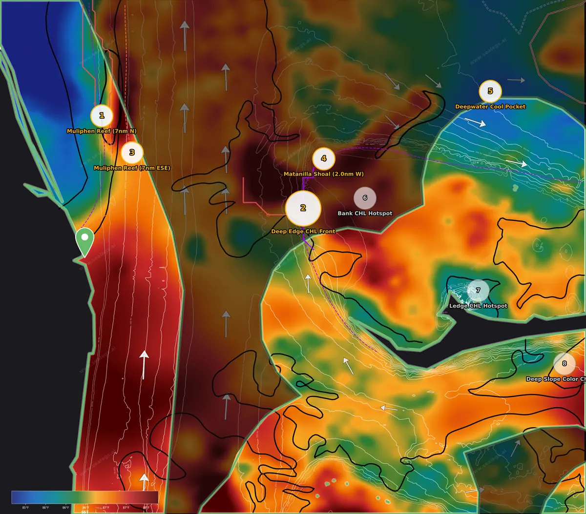
Friday weather: CAUTION. Winds stay under 9 knots ESE, but leftover 4.7-foot seas from the northeast take until mid-morning to drop toward 3 feet, and nearly three-quarters of an inch of rain is forecast. It's fishable for a well-found boat with a late start, but Saturday and Sunday are both GO with 2-foot or smaller seas — if you can pick, Sunday is the flattest.
The headline is the Muliphen Reef, about 35 miles up the coast from Jupiter Inlet. A sharp SST front runs north-south here with a 2.5°F break across a transition only 4 miles wide — the warm side lies east where Stream water sits near 87°F, the cooler shelf water inshore of it. This is the western wall of the Gulf Stream pinned against the shelf, and the strong thermal front here has held position for three days, long enough for bait to load up along it. The strong north-flowing current just outside the break keeps that edge tight. Water color shifts gradually greener toward the beach across a broad 17-mile transition (roughly 0.10 rising to 1.0 mg/m³), so treat that as general context rather than an edge to run — the temperature break is the line to fish. Troll the warm eastern side in the clean Stream water for blue marlin, which are right at home in 85–87°F, and work back across to the cooler inshore side where the shelf water bottoms out near 84°F for wahoo along the break. Keep an eye out for debris riding the edge for tripletail. Two wrecks lie 2 and 3 miles away over roughly 170 feet of bottom — when the trolling slows, drop for mutton snapper, grouper (check current regulations) and greater amberjack. Friday's moon is a growing crescent at about half-lit, a week out from full, so expect a steady daytime bite; the strongest feeding window falls around sunset, so it's worth staying through the last hour of light.
Closer to home, the Muliphen Reef sits about 28 miles out along a moderate SST color break with a 1.5°F step spread over 7 miles — a modest temperature change, not a hard edge, but it marks the Stream's inside boundary. The real draw here is the water column: the warm layer holds 84–85°F down to about 150 feet, then the steepest temperature drop runs from roughly 300 to 500 feet, bottoming near 62°F. That's a big thermocline over 700 feet of bottom, which sets up a daytime deep-drop for golden tilefish while you troll the surface edge for blue marlin. A closer run when the weather is questionable.
Two more spots fall in the inshore band on the Bahamas side and are only realistic for boats already over there or on an overnight. The Ledge CHL Hotspot shows a chlorophyll spike to 5.26 mg/m³ that has persisted three days over 366 feet of bottom, but at that concentration the green-brown water is more likely sediment or runoff than clean bait water — treat it as a snowy grouper and greater amberjack deep-drop spot on the ledge rather than a pelagic edge. The Deep Slope Color Change carries a moderate 1.3°F step across a 10-mile transition over 644 fathoms of clean blue water — a gradual warming rather than an edge, though the deep water and 86°F surface suit blue marlin if you're passing through.
Midshore (20-60nm)
The deep western edge of the Bahamas bank is the play, where clean Stream water meets green bank water over 1,280 feet of bottom — a swordfish deep-drop with blue marlin trolling on the blue side. Just inside it, a sharp 17-to-1 color change on the edge of Matanilla Shoal has held three days and sets up yellowtail, mutton and hogfish. Friday is CAUTION for rain; Saturday and Sunday are flat GO days.
- Fri Sep 18CAUTION
Friday is CAUTION due to over half an inch of forecast rain, which could reduce visibility despite winds staying under 9 knots. Seas run 2.3–3.4 feet at 6-second periods from the NNE, easing through the day. Not recommended for a 12-hour trip — wait for Saturday or Sunday.
- Sat Sep 19GO
Saturday is a GO day with light 3–9 knot ENE winds and seas easing from 2.2 feet to 1.5 feet at 5-second periods from the NNE. Any departure time works for a 12-hour trip, with the early morning hours offering the very best conditions. High forecast confidence.
- Sun Sep 20GO
Sunday is the calmest day of the window with near-zero winds in the morning and light 5–8 knot ESE breezes in the afternoon. Seas are just 0.9–1.5 feet at 5-second periods from the NE — the smoothest conditions of the three days. A GO all day with 89% forecast confidence.
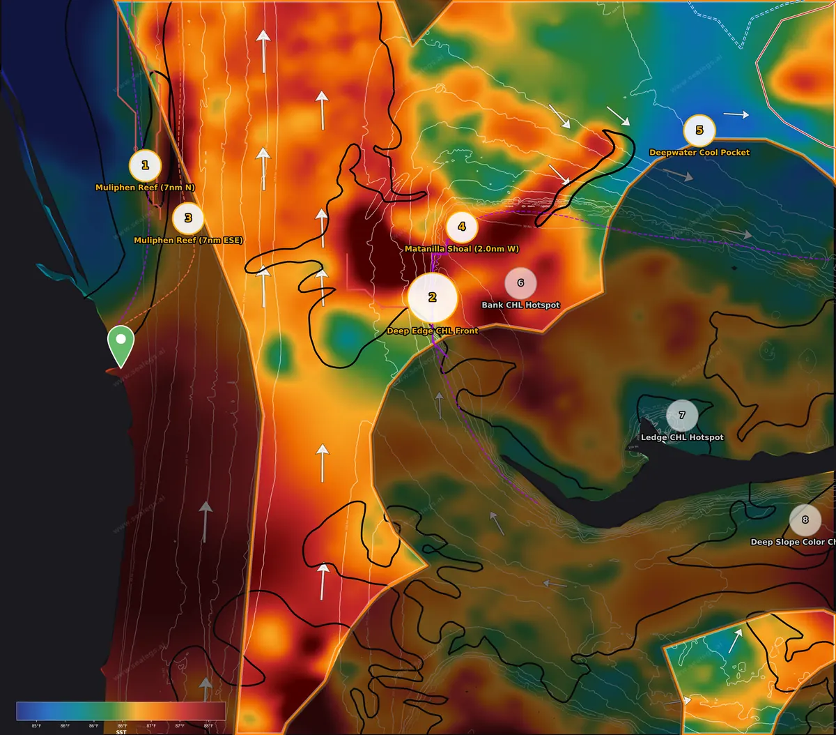
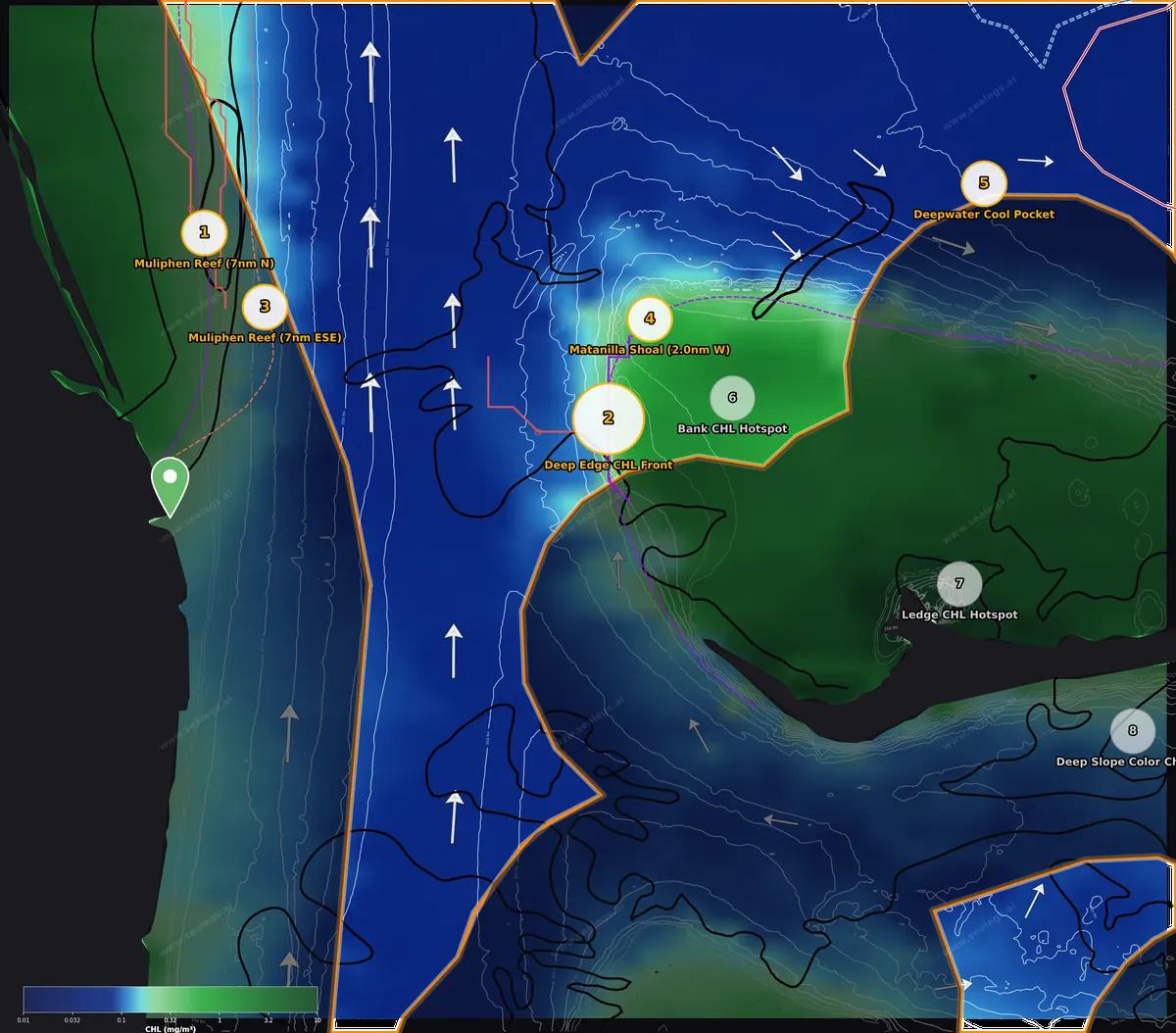
Friday weather: CAUTION. Seas are a manageable 2.3–3.4 feet from the NNE and winds stay under 9 knots, but more than half an inch of rain is forecast, which cuts visibility on a 50-mile run. Saturday is a clean GO and Sunday is near-glassy with 1-foot seas — for the bank crossing, Sunday is the day.
The Deep Edge CHL Front sits about 49 miles east of Jupiter Inlet where the deep western edge of the bank drops into the Stream. A sharp CHL front runs 43 km along this edge with the water 3.6 times greener on the eastern bank side (0.67 vs 0.19 mg/m³) — clean blue offshore water pressing against the productive bank water over a 9-mile transition. There's almost no temperature step across it (a weak 0.7°F break), so this is a color change to fish, not a thermal edge. A steady 0.6–0.9-knot current runs NNW along the edge and the flow is divergent across it, which tends to pull bait off the bank into the clean water. The bottom is the reason to commit a day here: 214 fathoms — about 1,280 feet — puts you squarely in daytime swordfish deep-drop range, with the temperature falling from 86°F at the surface through the steepest drop between 155 and 255 feet and down to 79°F by 300 feet. Rig a squid and work the bottom off the edge while a spread runs on the clean western side for blue marlin — sight feeders patrol the blue side where they can see bait coming off the green water. Debris pushed up along the color line is worth a look for tripletail.
A few miles north and up on the bank, the Matanilla Shoal marks the sharpest water color change in the whole area: a 17-to-1 shift from 0.09 to 1.49 mg/m³ across an 8-mile transition, and this line has held for three days. The spot sits two miles west of Matanilla Shoal and three miles east-southeast of White Sands in 84 feet, with a light northerly drift. The clean blue water lies west and the bait-rich green bank water east. This is bottom and reef fishing water — yellowtail snapper, mutton snapper and hogfish on the hard bottom around the shoal — and the sharp color edge tells you the bait is stacked right on the bank rim. Remember the Bahamas permit requirements before fishing this side.
Further east on the bank, the Bank CHL Hotspot shows a chlorophyll peak of 1.4 mg/m³ in green-brown water over 114 feet — moderate productivity that likely means forage on the bank, with a light current toward the NE. It's a secondary stop for mutton snapper and yellowtail snapper when you're already on the bank; nothing here justifies the 62-mile run on its own.
The one true pelagic feature at the far end of the zone is the Deepwater Cool Pocket, 97 miles from Jupiter north of the bank in 507 fathoms. A cool anomaly of 85.5°F has held two days against surrounding water pushing 87–88°F, with a 0.6-knot current setting ESE through it and the cleanest water in the area (chlorophyll near 0.05–0.07 mg/m³). A strong thermal front runs along the bank's north edge southwest of this pocket, so the cooler water has a defined boundary to fish. Blue marlin are the target in deep, clean 85°F water like this — work the edges of the cool pocket rather than the middle — and the coolest patches slide close enough to 85°F to give wahoo a chance on a high-speed spread. This is an overnight or Bahamas-based run, not a day trip from Jupiter, and Friday's rain makes Saturday or Sunday the better crossing days.
Offshore (60-150nm)
No qualifying features in the offshore band this week — the water out there is uniform 86°F clean blue with no breaks or color changes to lean on. Weather is GO all three days, but with nothing to target, the midshore bank edge is the better use of fuel.
- Fri Sep 18GO
Friday is a GO all day with light east-southeast winds and seas under 1.5 feet. Best conditions arrive mid-morning as winds ease to 2–5 knots from the NNE. Gust forecasts have some model spread, so monitor conditions as you go.
- Sat Sep 19GO
Saturday is the best day of the forecast with 94% model confidence. East winds stay at 3–9 knots all day and seas remain under 1.1 feet from the ESE. Any departure time works, but 10:00 AM is the sweet spot.
- Sun Sep 20GO
Sunday offers the calmest conditions of the weekend with near-glassy seas under 0.6 feet and winds often below 3 knots. Any departure time works for a 12-hour trip. Some model spread on wind direction, but the overall outlook stays very favorable.
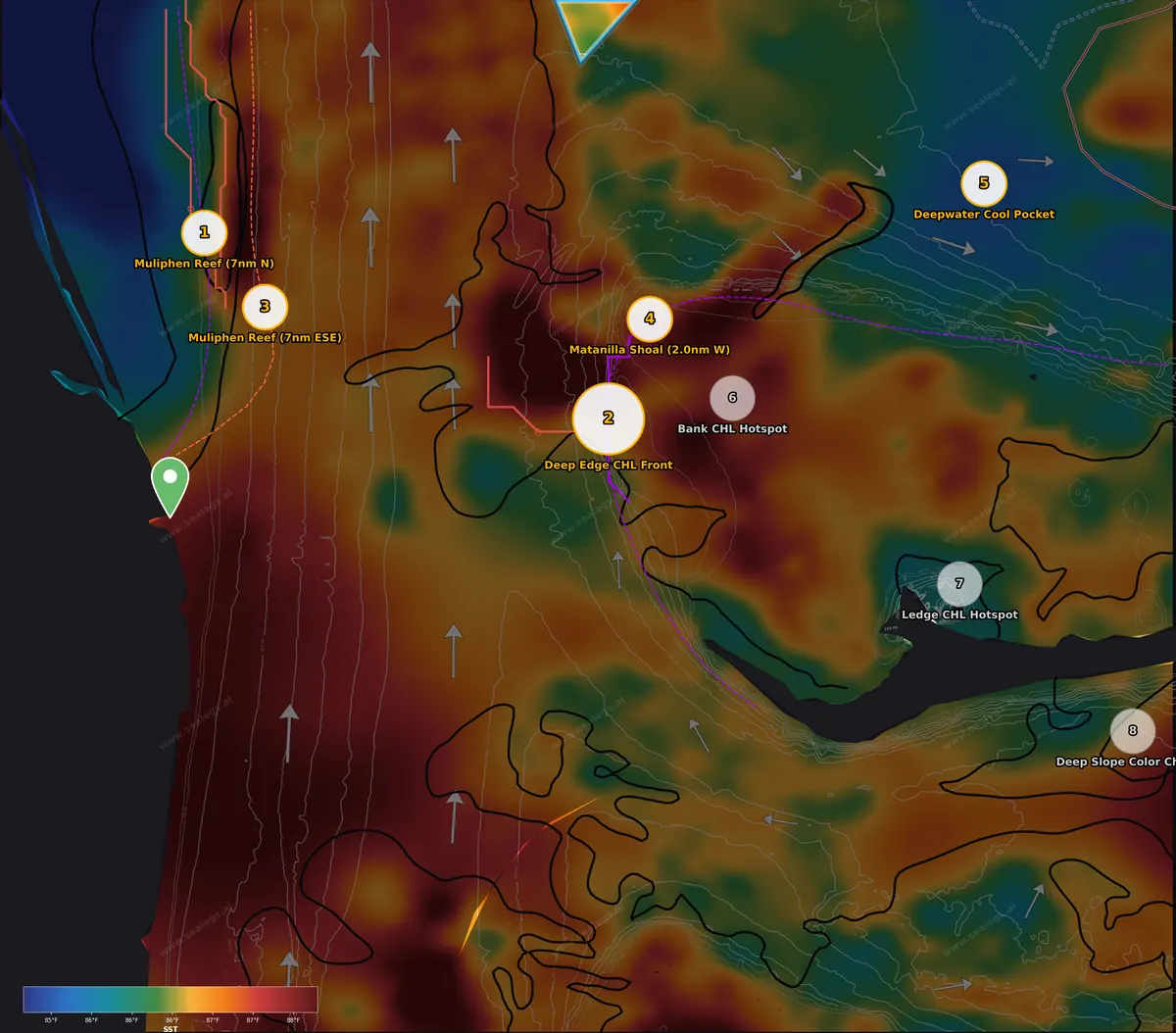
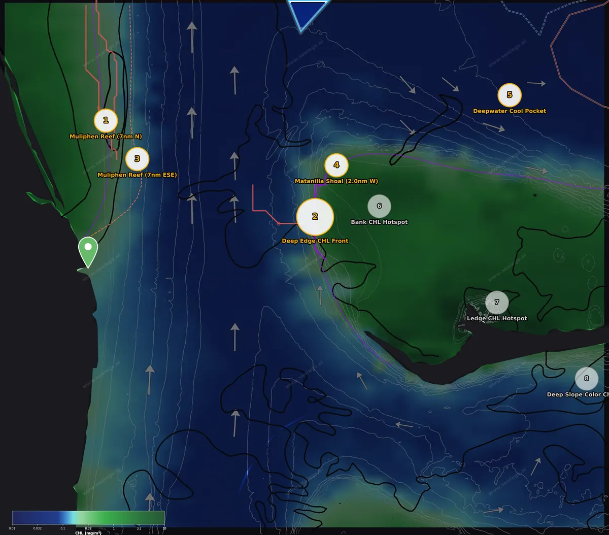
Friday weather: GO — light ESE winds and seas under 1.5 feet, and it only gets calmer through the weekend. The trouble is the water itself: the small slice of true offshore water in reach shows a tight 85.5–86.9°F range and chlorophyll flat around 0.06 mg/m³ with no temperature break, color change or convergence to work. If you're already that far east in the Bahamas, blind-troll the deep blue water for blue marlin around the strong thermal front that runs off the north edge of the bank, or head back west to the midshore bank edge where the color change and swordfish bottom are. Otherwise, spend the day on the shelf-edge break north of Muliphen Reef instead.
Top spots this week
Ranked by signal strength, how long the feature has held, and how far the run is.
- 1
7 nm N of Muliphen Reef
Inshore · 85.3°F · Blue marlin, wahoo, tripletail, mutton snapper, grouper, greater amberjack
Sharp 2.5°F Gulf Stream front over a 4-mile transition, held three days over the shelf with wrecks 2–3 miles away — the only significant temperature break in reach and the best multi-option day (blue marlin and wahoo on the edge, mutton and amberjack on the wrecks). 35 miles from port; Friday is CAUTION with rain and easing seas, so start mid-morning and stay through the sunset feeding window, or take Saturday's GO.
- 2
Deep Edge CHL Front
Midshore · 85.7°F · Swordfish, blue marlin, tripletail
Sharp 3.6x clean-to-green color change with a steady NNW current on the deep bank edge, sitting over 1,280 feet of swordfish deep-drop bottom with a defined thermocline at 155–255 feet. Swordfish on the bottom plus blue marlin on the blue side. 49 miles; CAUTION Friday for rain, glassy Sunday is the ideal crossing.
- 3
7 nm ESE of Muliphen Reef
Inshore · 84.7°F · Blue marlin, golden tilefish
Closest option at 28 miles with a moderate 1.5°F step on the Stream's inside edge and a deep thermocline dropping to 62°F by 500 feet over 700-foot bottom — troll for blue marlin while deep-dropping for golden tilefish. A sensible shorter run on a CAUTION Friday.
- 4
2.0 nm W of Matanilla Shoal
Midshore · 86.7°F · Yellowtail snapper, mutton snapper, hogfish
The sharpest color change in the area — 17-to-1 across 8 miles, persistent for three days — right on the bank rim in 84 feet with Matanilla Shoal and White Sands structure within three miles. Reliable yellowtail, mutton and hogfish for a Bahamas-side day; pairs naturally with the deep edge front a few miles south.
- 5
Deepwater Cool Pocket
Midshore · 85.5°F · Blue marlin, wahoo
The best pure marlin water in the area: a persistent 85.5°F cool pocket in ultra-clean deep water with a strong thermal front along the bank edge nearby and current setting through it. Ranks last only because of the 97-mile run — an overnight or Bahamas-based play, best under Saturday or Sunday's flat GO conditions.
Run distances from your inlet
Straight-line distance and heading from each inlet to this week's ranked spots. Plan fuel for the real route, and for the ride home.
From Sebastian Inlet
This week's #1 spot, 7 nm N of Muliphen Reef, is 31 nm SE (131°).
From Fort Pierce Inlet
This week's #1 spot, 7 nm N of Muliphen Reef, is 16 nm E (079°).
From Stuart (St. Lucie Inlet)
This week's #1 spot, 7 nm N of Muliphen Reef, is 23 nm NNE (020°). The closest ranked spot is #3 7 nm ESE of Muliphen Reef, 19 nm NE in the inshore zone.
From Jupiter Inlet
This week's #1 spot, 7 nm N of Muliphen Reef, is 35 nm N (006°). The closest ranked spot is #3 7 nm ESE of Muliphen Reef, 28 nm NNE in the inshore zone. This week's report was run from here.
From Palm Beach Inlet
This week's #1 spot, 7 nm N of Muliphen Reef, is 45 nm N (002°). The closest ranked spot is #3 7 nm ESE of Muliphen Reef, 37 nm NNE in the inshore zone.
From Boynton Inlet
This week's #1 spot, 7 nm N of Muliphen Reef, is 59 nm N (002°). The closest ranked spot is #3 7 nm ESE of Muliphen Reef, 50 nm N in the inshore zone.
From Boca Raton Inlet
This week's #1 spot, 7 nm N of Muliphen Reef, is 71 nm N (003°). The closest ranked spot is #3 7 nm ESE of Muliphen Reef, 63 nm N in the inshore zone.
From Hillsboro Inlet
This week's #1 spot, 7 nm N of Muliphen Reef, is 76 nm N (003°). The closest ranked spot is #3 7 nm ESE of Muliphen Reef, 68 nm N in the inshore zone.
From Fort Lauderdale (Port Everglades)
This week's #1 spot, 7 nm N of Muliphen Reef, is 86 nm N (004°). The closest ranked spot is #3 7 nm ESE of Muliphen Reef, 78 nm N in the inshore zone.
About the Jupiter & Palm Beach fishing report
This is the weekly Jupiter offshore fishing report from SeaLegs AI. Every week we run a full DeepCast report out of Jupiter Inlet and publish it here: satellite sea surface temperature and chlorophyll, where the Gulf Stream edge and the color changes sit, the ledges and wrecks they cross, and a GO / CAUTION / NO-GO boating call for the inshore, midshore and offshore water.
The Stream runs closer to the beach here than anywhere else on the East Coast, often within a few miles of Jupiter and Palm Beach, so the inshore zone on this report is often blue water. One report covers the coast from Sebastian Inlet down to Fort Lauderdale. Distances from each inlet to this week's spots are listed below.
Jupiter & Palm Beach fishing report FAQ
What is the offshore fishing outlook off Jupiter Inlet this week?
No qualifying features in the offshore band this week — the water out there is uniform 86°F clean blue with no breaks or color changes to lean on. Weather is GO all three days, but with nothing to target, the midshore bank edge is the better use of fuel.
How is the midshore fishing off Jupiter Inlet this week?
The deep western edge of the Bahamas bank is the play, where clean Stream water meets green bank water over 1,280 feet of bottom — a swordfish deep-drop with blue marlin trolling on the blue side. Just inside it, a sharp 17-to-1 color change on the edge of Matanilla Shoal has held three days and sets up yellowtail, mutton and hogfish. Friday is CAUTION for rain; Saturday and Sunday are flat GO days.
Where is the best inshore fishing near Jupiter Inlet this week?
Best bet is the Stream edge north of Muliphen Reef, where a sharp 2.5°F break that has held for three days sits over the shelf with wrecks close by — troll the warm Stream side for blue marlin, work the cooler inshore side for wahoo, and drop on the wrecks for mutton and amberjack when the trolling slows. The break east-southeast of Muliphen Reef is a closer, softer version with tilefish bottom below. Friday is CAUTION with rain and easing seas; Saturday and Sunday are clean.
How far are this week's spots from Sebastian Inlet, Fort Pierce Inlet, Stuart (St. Lucie Inlet), Jupiter Inlet, Palm Beach Inlet, Boynton Inlet, Boca Raton Inlet, Hillsboro Inlet and Fort Lauderdale (Port Everglades)?
The run-distance table on this page gives the straight-line distance and heading from each inlet to this week's number one spot and to the closest ranked spot.
How often is the Jupiter & Palm Beach fishing report updated?
Every week. Each week SeaLegs AI features one DeepCast report for the Jupiter & Palm Beach region, and this page is rebuilt from it. This edition was written for Friday, September 18, 2026 out of Jupiter Inlet.
What is DeepCast?
DeepCast is SeaLegs AI's offshore fishing report. It reads satellite sea surface temperature, chlorophyll, currents and bathymetry around your departure port, finds temperature breaks and color edges, ranks the spots worth running to, and pairs them with a GO / CAUTION / NO-GO boating forecast for each zone. You can run one for any port for $4.99.
Get this report for your own inlet
This is one featured DeepCast report a week. In the SeaLegs AI app you can run one out of any port, for any day, whenever you want: temperature breaks, color edges, ranked spots, and a GO / CAUTION / NO-GO call for each zone. $4.99 a report, no subscription.


Decision-support guidance only. Marine weather can change rapidly, and conditions on the water often differ from forecasts. The captain is solely responsible for all go/no-go decisions and must check the official NWS marine forecast and warnings before getting underway. Satellite data: NASA, Copernicus Marine, Open-Meteo, DWD.