A Special Marine Warning (SMW) is an urgent alert issued by NOAA's National Weather Service when a sudden, severe, short-lived hazard is about to strike coastal, nearshore, or Great Lakes waters. It means sustained winds or gusts of 34 knots (about 39 mph) or more, large hail, or waterspouts are occurring or imminent — and that you should get off the water or seek shelter now.
It's almost always a thunderstorm or squall. And it's the marine alert that catches the most boaters off guard, because it can appear an hour after you left the dock under blue sky. A Special Marine Warning is the National Weather Service telling you: this isn't on the long-range forecast — it's happening, and it's headed your way.
What triggers a Special Marine Warning?
The National Weather Service issues a Special Marine Warning for a brief, intense event — usually lasting under two hours — that meets any one of these criteria over a marine area not already covered by an existing warning:
| Trigger | Threshold |
|---|---|
| Wind | Sustained winds or frequent gusts of 34 knots (39 mph) or greater |
| Hail | 3/4 inch in diameter or larger |
| Waterspouts | Any waterspout affecting the marine area |
| Short-fused systems | Squall lines, gravity waves, or a strong cold front lasting under 2 hours and producing winds/gusts of 34 kt+ |
That 34-knot number is the same wind threshold as a Gale Warning — but the two are used differently. A Gale Warning is for a broad, sustained wind event you can see coming hours ahead. A Special Marine Warning is for a fast-moving cell: here in fifteen minutes, gone in ninety.
How long does a Special Marine Warning last?
Most Special Marine Warnings cover a short window — typically two hours or less — because the storms that cause them move through quickly. If the threat keeps going, the National Weather Service issues a fresh warning or a follow-up Marine Weather Statement rather than stretching the original one.
Short duration is exactly what makes an SMW dangerous. The window is narrow, the onset is sudden, and the gap between "fine" and "40-knot gusts with a waterspout" can be a quarter of an hour.
Just got a Special Marine Warning? Check these 3 things first.
- Your exact wind & gust forecast for the next 1–2 hours — not the zone average.
- Wave height and period on your route — short-period chop is what flips small boats.
- A clear Go / Avoid call for your exact spot and the time you're heading in.
What to do when you get a Special Marine Warning
An SMW is a warning, which in National Weather Service language means the hazard is occurring or imminent — not "possible." Act on it:
- Head for the nearest safe harbor immediately. Don't try to outrun a cell to a farther destination — get to the closest shelter.
- If you can't reach shelter in time, prepare the boat. Life jackets on everyone, close hatches and ports, secure loose gear, and keep the bow into the wind and waves at a slow, steady speed.
- Monitor VHF channel 16 and NOAA Weather Radio. Updates and the all-clear come through there first.
- Don't trust the blue sky. Special Marine Warnings routinely arrive ahead of a storm that isn't overhead yet. The warning is the lead time — use it.
It's assuming a clear departure means a clear return. A Special Marine Warning is the single most common way a calm morning turns dangerous — the storm builds and moves faster than most boaters expect.
Special Marine Warning vs. other marine alerts
An SMW is one rung on NOAA's ladder of marine products. Here's how it lines up against the alerts it's most often confused with:
| Alert | What it signals | Urgency |
|---|---|---|
| Special Marine Warning | Sudden, severe, short-lived storm: 34 kt+ wind, hail, or waterspouts | Act now |
| Small Craft Advisory | Sustained conditions (~20–33 kt or rough seas) dangerous to small boats | Caution / usually don't go |
| Marine Weather Statement | Information: a follow-up or developing conditions that don't meet warning criteria | Heads-up |
| Severe Thunderstorm Warning | The same kind of storm, but for land areas | Act now (on land) |
The most useful comparison is the last one. A Special Marine Warning is the water equivalent of a Severe Thunderstorm Warning. When a severe storm moves off the coast or out onto a lake, the National Weather Service issues an SMW so boaters get the same urgent alert that drivers and homeowners get on land. For the full picture of how every marine alert ranks, see our guide to what a marine warning is.
How Special Marine Warnings reach you — and the gap they leave
Special Marine Warnings are broadcast over NOAA Weather Radio (VHF), announced on VHF channel 16 and Coast Guard channels, and posted on National Weather Service marine pages. Because they're a tornado-class severe product, many are also pushed to phones as Wireless Emergency Alerts. They're free, authoritative, and you should always have a VHF aboard.
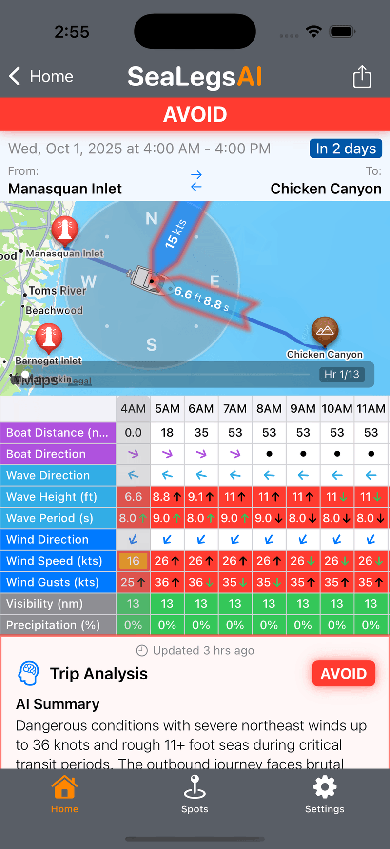
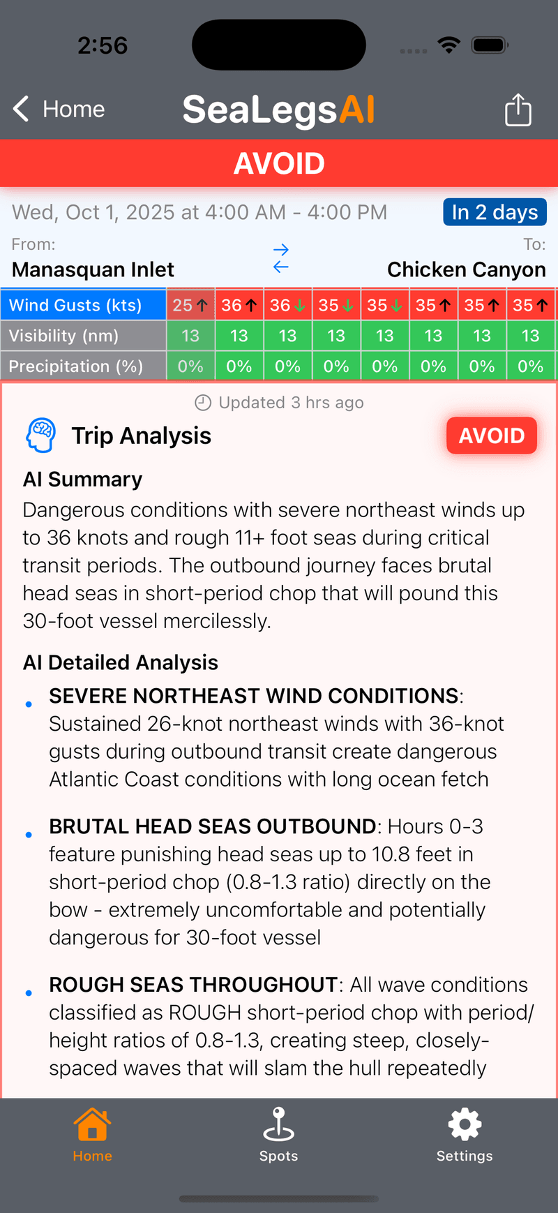
The catch is that an SMW is issued for a broad marine zone — sometimes hundreds of square miles. It tells you the zone is dangerous. It can't tell you whether the inlet you're running, at the time you're running it, is the bad part of that zone or the edge that's already clearing.
SeaLegs AI closes that gap: it combines the official NOAA zone warnings with point-specific wind, gust, wave height, and wave-period forecasts for your exact launch spot and departure time, then turns it into a plain Go, Caution, or Avoid call. The warning tells you the zone is dangerous; SeaLegs tells you whether your window is the part to avoid.
The bottom line
- A Special Marine Warning is NOAA's alert for a sudden, severe, short-lived marine storm — 34 kt+ wind, 3/4-inch hail, or waterspouts.
- It usually lasts two hours or less, and it's the alert most likely to appear after a clear-sky departure.
- It's a warning, not a watch or advisory — the hazard is happening or imminent. Get off the water or to shelter.
- It's the marine version of a Severe Thunderstorm Warning — same storm, water instead of land.
- The official warning covers a whole zone; a point forecast tells you whether your exact spot and time are the dangerous part.